Filter: Categories of Wisconsin Historical Images
Filter: Subject of Railroads
Filter: Subject of cities and towns
Filter: Categories of Wisconsin Historical Images
Filter: Subject of Railroads
Filter: Subject of cities and towns
| Date: | 1919 |
|---|---|
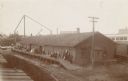
| Description: | View across railroad tracks towards the Sullivan Condensed Milk Company. There is a train in front of the factory building. Caption reads: "Sullivan Conden... |

| Date: | 1855 |
|---|---|
| Description: | Map of the city of Madison, Dane County, published by George Harrison, surveyed and drawn by P. McCabe, and engraved by J.H. Colton & Co., New York. In add... |

| Date: | 1950 |
|---|---|
| Description: | An aerial view of town, showing a major industrial area. |

| Date: | 1935 |
|---|---|
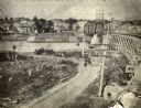
| Description: | An aerial view of numerous Manitowoc factories/industries. |
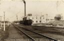
| Date: | 1895 |
|---|---|
| Description: | View across railroad tracks towards the Wisconsin Central railroad station. Caption reads: "Soo Line Passenger Depot, Stevens Point, Wis." |
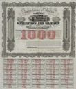
| Date: | 1857 |
|---|---|
| Description: | One thousand dollar bond and coupons issued by the Watertown and Madison Railroad Company in 1857. Jairus Fairchild, president, and T.L. Lawrence have sig... |
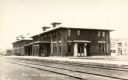
| Date: | 1915 |
|---|---|
| Description: | View across railroad tracks towards the Chicago, Milwaukee, & Sault Sainte Marie Railway Depot. In the background on the right is the Star Restaurant. Capt... |
| Date: | 07 31 1975 |
|---|---|
| Description: | Exterior view of the Milwaukee Road railroad station on the last day of operation by the line. |
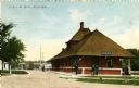
| Date: | 1905 |
|---|---|
| Description: | View of the Chicago and Northwestern Railway depot with several people standing outside around it. Caption reads: "C. & N. W. Depot, Ripon, Wis." |
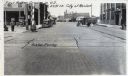
| Date: | 1925 |
|---|---|
| Description: | View of the railroad crossing where rubber paving was used for the first time in the United States. Caption at top reads: "First Rubber Crossing in U.S. S.... |
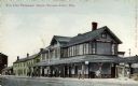
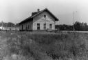
| Date: | 1900 |
|---|---|
| Description: | View of the Racine and Mississippi freight and passenger depot with multiple individuals lined up on the platform. |

| Date: | 1880 |
|---|---|
| Description: | This map shows railroads by operator and projected railroads. Portions of Lake Michigan, Lake Superior, Illinois, Iowa, Michigan and Minnesota are labeled. |
| Date: | 1886 |
|---|---|
| Description: | View of the Chicago, Burlington, and Quincy railroad drawbridge and trestle. |

| Date: | 1896 |
|---|---|
| Description: | Map showing the Wisconsin Central Railroad and its land grant, with the railroad and the land grant in color (red). |

| Date: | 1909 |
|---|---|
| Description: | [Lithography] by Poole Bros. Contains descriptive information. Short jaunts for busy people to nearby resorts in Illinois and Wisconsin. |

| Date: | |
|---|---|
| Description: | Plat map of the east central part of the city. |

| Date: | 1882 |
|---|---|
| Description: | This basic reference map of the state shows natural features, railroads, county seats, and political boundaries against the G.L.O. township and range grid.... |

| Date: | 1868 |
|---|---|
| Description: | Showing the counties, towns and railroads. Partly colored. Scale: 1 inch = 20 miles. |
If you didn't find the material you searched for, our Library Reference Staff can help.
Call our reference desk at 608-264-6535 or email us at: