 Filter: Categories of Wisconsin Historical Images
Filter: Subject of Railroads
Filter: County of Trempealeau
Filter: Categories of Wisconsin Historical Images
Filter: Subject of Railroads
Filter: County of Trempealeau

| Date: | 1877 |
|---|---|
| Description: | This 1877 map of Trempealeau County, Wisconsin, shows the township and range grid, sections, towns, cities and villages, land ownership and acreages, roads... |

| Date: | 1929 |
|---|---|
| Description: | This 1929 topographic map of Trempealeau County, Wisconsin, shows the topography, lakes, streams and wetlands, township and range grid, sections, cities an... |

| Date: | 1854 |
|---|---|
| Description: | This map is mounted on cloth and shows lot and block numbers, streets, additions, and public squares. Also included is information on Trempealeau, an inset... |

| Date: | 1920 |
|---|---|
| Description: | This blue print map shows landownership between 1913 and 1916, topography, railroads, and roads. The map covers the vicinity of Perrot State Park. |
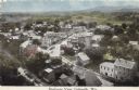
| Date: | |
|---|---|
| Description: | View of the main street and railroad tracks going through Galesville and the surrounding neighborhoods. Fields and hills are in the distance. |
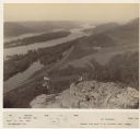
| Date: | 1880 |
|---|---|
| Description: | Elevated view of two men on a rock formation in the foreground, one man sitting, and one man standing holding a flag. Below them is the Mississippi River a... |
If you didn't find the material you searched for, our Library Reference Staff can help.
Call our reference desk at 608-264-6535 or email us at: