 Filter: Categories of Wisconsin Historical Images
Filter: Subject of Railroads
Filter: County of Sheboygan
Filter: Categories of Wisconsin Historical Images
Filter: Subject of Railroads
Filter: County of Sheboygan
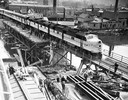
| Date: | 05 03 1948 |
|---|---|
| Description: | Elevated view of a Chicago and Northwestern passenger train, which is the first across a new bridge in Sheboygan. There is a group of people standing near ... |
| Date: | 1941 |
|---|---|
| Description: | A map shows early settlers by name and date, industries, the Chicago & North Western rail line, roads, and depths and net lines in Lake Michigan. Text prov... |

| Date: | 1862 |
|---|---|
| Description: | This 1862 map of Sheboygan County, Wisconsin, shows land ownership and acreages, the township and range grid, towns, cities and villages, roads, railroads,... |

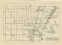
| Date: | 1906 |
|---|---|
| Description: | This map of Sheboygan County, Wisconsin, from the early 20th century shows school districts and school locations in the county. Also shown are the township... |

| Date: | 1972 |
|---|---|
| Description: | This map of Sheboygan County, Wisconsin, shows the location of churches in the county. Churches are indexed for each town. Also shown are sections, cities ... |

| Date: | 1898 |
|---|---|
| Description: | This map shows the contour depths of Elkhart Lake in the Town of Rhine, Sheboygan County, Wisconsin, and includes two cross sections of the lake. The villa... |

| Date: | 1862 |
|---|---|
| Description: | Shows townships and sections, landownership and acreage, roads, railroads, churches, schools, and cemeteries. Inset maps: Plat of Hingham -- Plat of Casca... |

| Date: | 1893 |
|---|---|
| Description: | This map shows wards, railroads, street cars, streets, lot and block numbers, landownership, parks, hospitals, the Sheboygan River, and Lake Michigan. Ward... |

| Date: | 1915 |
|---|---|
| Description: | This map shows wards, railroads, street railways, streets, lot and block numbers, parks, and hospitals. Also included are manuscript annotations of points ... |

| Date: | 1959 |
|---|---|
| Description: | This map shows some land ownership, lot and block numbers, additions, fair grounds, streets, and railroads and is indexed. Mullet River and Mill Pond are l... |

| Date: | 1894 |
|---|---|
| Description: | This map shows railroads, street railways, ward lines, land parcels, streets, schools and public buildings. Ward lines are highlighted in red. Lake Michiga... |
If you didn't find the material you searched for, our Library Reference Staff can help.
Call our reference desk at 608-264-6535 or email us at:
