 Filter: Categories of Wisconsin Historical Images
Filter: Subject of Railroads
Filter: County of Milwaukee
Filter: Categories of Wisconsin Historical Images
Filter: Subject of Railroads
Filter: County of Milwaukee

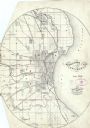
| Date: | 1914 |
|---|---|
| Description: | A hand-drawn and colored map of the Milwaukee Township, showing how lands were used, included are parks, cemeteries, private grounds, and speculative land.... |

| Date: | 1854 |
|---|---|
| Description: | Reproduction printed on glossy, cloth-backed paper. Right side includes "References," or points of interest that correspond to numbers on the map. Running ... |
| Date: | 06 1858 |
|---|---|
| Description: | This map shows additions and subdivisions to Milwaukee, city wards, roads, railroads, and selected buildings. This map was engraved to accompany the city d... |

| Date: | 1861 |
|---|---|
| Description: | Map with labelled block and lot numbers, owners of large property parcels, city wards, railroads, and streets. Population from 1835 to 1860 listed below ti... |

| Date: | 05 1958 |
|---|---|
| Description: | Photocopy of a map created by the City of Milwaukee Master Plan Program City Planning Division in May of 1958 representing 1870 "THE CENTRAL AREA OF THE CI... |

| Date: | 1880 |
|---|---|
| Description: | Map created from original drawing and surveys taken by Silas Chapman. Bottom right corner features a reference key. There is a street guide on the left sid... |

| Date: | 1927 |
|---|---|
| Description: | Street railway and motor bus map with a legend of "Street Car Line," "Auxiliary Bus Lines," and "Motor Bus Lines." The routes are numbered. The map reads: ... |

| Date: | 1886 |
|---|---|
| Description: | Map shows townships, post offices, roads, railroads, and selected buildings. The sections are in pink, green, blue, and yellow. Counties, towns, and lakes ... |

| Date: | 1903 |
|---|---|
| Description: | Map shows railroads, roads, street car lines, schools, churches, cemeteries, town halls, and railroad stations. Includes inset lists of: Population of Milw... |

| Date: | 1860 |
|---|---|
| Description: | Map shows meadows, forests, buildings, railroad, and lots south of part of the city of Milwaukee. Relief shown by hachures. Includes list of lot acreages. |

| Date: | 1881 |
|---|---|
| Description: | Bird's-eye view of Milwaukee from the south lakeshore. |
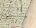
| Date: | 1893 |
|---|---|
| Description: | Detail of a Milwaukee County map that shows sections 20 and 21 at Range 22 East, Township 8 North. |
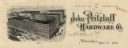
| Date: | |
|---|---|
| Description: | Letterhead of the John Pritzlaff Hardware Company, with an elevated three-quarter view of the company building. |

| Date: | 1855 |
|---|---|
| Description: | This map shows lot and block numbers, buildings, some landownership, roads, railroads, cemeteries, the Milwaukee River, and Lake Michigan. The map includes... |

| Date: | 1856 |
|---|---|
| Description: | This map shows lot and block numbers, wards, roads, railroads, and some landowner names. Lake Michigan and the Milwaukee River are labeled. Includes an ins... |

| Date: | 1857 |
|---|---|
| Description: | This map shows lot and block numbers, wards, roads, railroads, some landowners’ names, and selected buildings. The map includes an inset map of Glidden & L... |

| Date: | 1857 |
|---|---|
| Description: | This map shows lot and block numbers, wards, roads, railroads, some landowners’ names, and selected buildings. Lake Michigan, the Milwaukee River, and Glid... |

| Date: | 1857 |
|---|---|
| Description: | This map shows lot and block numbers, wards, roads, railroads, some landowners’ names, and selected buildings. Lake Michigan, the Milwaukee River, and Glid... |

| Date: | 1868 |
|---|---|
| Description: | This map shows lot and block numbers, some property ownership, wards, roads, and railroads. An inset map shows the Glidden & Lockwood’s addition. There are... |

| Date: | 1869 |
|---|---|
| Description: | This map shows lot and block numbers, some property ownership, wards, roads, and railroads and includes inset map of Glidden & Lockwood’s addition. There a... |
If you didn't find the material you searched for, our Library Reference Staff can help.
Call our reference desk at 608-264-6535 or email us at: