 Filter: Categories of Wisconsin Historical Images
Filter: Subject of Railroads
Filter: County of Milwaukee
Filter: Categories of Wisconsin Historical Images
Filter: Subject of Railroads
Filter: County of Milwaukee

| Date: | 1950 |
|---|---|
| Description: | An original color lithograph featuring a side profile view of The Milwaukee Road Hiawatha engine and one additional car. Below the image is written: "Built... |

| Date: | 09 10 1946 |
|---|---|
| Description: | Young worker operates a large lever on railroad tracks. Part of a series on working conditions aboard Lake Michigan railroad car ferries. Ferry workers bel... |
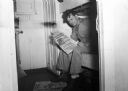
| Date: | 09 10 1946 |
|---|---|
| Description: | Worker reads union newspaper while sitting on a bunk and smoking a cigar. Part of a series on working conditions aboard Lake Michigan railroad car ferries.... |
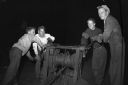
| Date: | 09 15 1946 |
|---|---|
| Description: | Four workers operating an "ancient" winch. Part of a series on working conditions aboard Lake Michigan railroad car ferries. Ferry workers belonged to the ... |
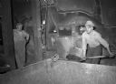
| Date: | 09 15 1946 |
|---|---|
| Description: | Workers shoveling coal into furnace. Part of a series on working conditions aboard Lake Michigan railroad car ferries. Ferry workers belonged to the Nation... |
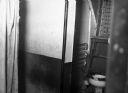
| Date: | 09 15 1946 |
|---|---|
| Description: | Workers' toilet. Part of a series on working conditions aboard Lake Michigan railroad car ferries. Ferry workers belonged to the National Maritime Union (N... |

| Date: | 01 01 1940 |
|---|---|
| Description: | Engine #934 of the Chicago, Milwaukee, St. Paul and Pacific Railroad Company. |

| Date: | 1878 |
|---|---|
| Description: | This map shows block numbers, wards, roads, railroads, parks, and selected buildings and includes a "Milwaukee city street guide" as well as a guide to pub... |

| Date: | |
|---|---|
| Description: | Memohead of the Joseph Schlitz Brewing Company of Milwaukee, Wisconsin, with an elevated view of the brewery complex, including an elevator and other stora... |

| Date: | |
|---|---|
| Description: | Letterhead of the Phillip Best Brewing Company of Milwaukee, Wisconsin, with three separate proscenium views of the Empire Brewery, the South Side Brewery,... |

| Date: | 1887 |
|---|---|
| Description: | This map shows block numbers, roads, railroads, wards, and selected buildings. The map includes a "Milwaukee city street guide" and index to public buildin... |

| Date: | 1858 |
|---|---|
| Description: | An ink on paper map of Milwaukee County and the eastern portion of Waukesha County that shows the townships of Oak Creek, Franklin, Greenfield, Wauwatosa, ... |
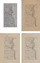
| Date: | 1875 |
|---|---|
| Description: | A series of four, ink on tracing cloth maps of Milwaukee County, Wisconsin that show the topography, the Milwaukee and Menomonee rivers, and railroad of th... |

| Date: | 1886 |
|---|---|
| Description: | A hand-colored map of Milwaukee County, Wisconsin that shows the township and range system, sections, towns, roads, railroads and rail stations, cities and... |

| Date: | 1891 |
|---|---|
| Description: | A hand-colored map of Milwaukee County, Wisconsin that shows the township and range system, sections, towns, roads, railroads and rail stations, cities and... |

| Date: | 1896 |
|---|---|
| Description: | A map of Milwaukee County, Wisconsin that shows the township and range system, sections, towns, roads, railroads and rail stations, cities and villages, po... |

| Date: | 1902 |
|---|---|
| Description: | A map of Milwaukee County, Wisconsin that shows the township and range system, sections, towns, roads, railroads and rail stations, cities and villages, po... |

| Date: | 1922 |
|---|---|
| Description: | A road map of Milwaukee County, Wisconsin that shows the township and range system, towns, communities, completed roads, a proposed system of roads, steam ... |

| Date: | 1940 |
|---|---|
| Description: | Map of Milwaukee County showing the metropolitan area, in yellow, and the proposed connecting of parkways and boulevards in green. The map also identifies ... |

| Date: | 1849 |
|---|---|
| Description: | A hand-drawn map of showing the two proposed routes from the Milwaukee River to the Moody’s Lime Quarry at Milwaukee, Wisconsin. The map includes the route... |
If you didn't find the material you searched for, our Library Reference Staff can help.
Call our reference desk at 608-264-6535 or email us at: