 Filter: Categories of Wisconsin Historical Images
Filter: Subject of Railroads
Filter: County of Milwaukee
Filter: Categories of Wisconsin Historical Images
Filter: Subject of Railroads
Filter: County of Milwaukee

| Date: | 1900 |
|---|---|
| Description: | This map shows landownership, railroads, roads, churches, schools, cemeteries, post offices, townships, city wards, Lake Michigan, and rivers. The map incl... |
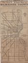
| Date: | 1923 |
|---|---|
| Description: | This map shows state, county, and city roadways as well as neighborhoods. Lake Michigan is on the far right. |

| Date: | 2000 |
|---|---|
| Description: | This map shows the industrial area along the Menominee River and canals. Industrial buildings are shown in orange and labeled in red. Other areas are shown... |
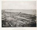
| Date: | 1892 |
|---|---|
| Description: | Bird's-eye view of Cudahy showing stock yards and the Cudahy packing houses. A train runs through the center of the image on the Chicago & Northwestern Rai... |

| Date: | 1892 |
|---|---|
| Description: | Engraving of an elevated view of the Pfister and Vogel Leather Company Menomonee Tannery in Milwaukee. A railroad runs along the side of the factory. Pleas... |

| Date: | 1960 |
|---|---|
| Description: | Construction Equipment Division. |

| Date: | 1880 |
|---|---|
| Description: | A map of Milwaukee which includes a city street guide. |
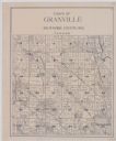
| Date: | 1920 |
|---|---|
| Description: | A plat map of the town of Granville in Milwaukee County, Wisconsin. |
If you didn't find the material you searched for, our Library Reference Staff can help.
Call our reference desk at 608-264-6535 or email us at:

