 Filter: Categories of Wisconsin Historical Images
Filter: Subject of Railroads
Filter: County of Iowa
Filter: Categories of Wisconsin Historical Images
Filter: Subject of Railroads
Filter: County of Iowa
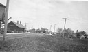
| Date: | 1925 |
|---|---|
| Description: | Railroad depot taken as part of a survey by the Wisconsin Power and Light Company to promote economic development by emphasizing available buildings and bu... |

| Date: | 1870 |
|---|---|
| Description: | A map of Iowa County, Wisconsin mounted on cloth that shows the villages of Avoca, Mifflin, Linden, Arena, Helena Station, Highland, Dodgeville, as well as... |

| Date: | 1901 |
|---|---|
| Description: | A hand-colored map of Iowa County, Wisconsin, shows townships and sections, towns, cities and villages, streams, landownership, roads, railroads and rural ... |

| Date: | 1956 |
|---|---|
| Description: | Shows roads, railroads, highways, boundaries, and other public facilities and areas. Includes location map and legend. "Corrected for Feb. 1956." "Correcte... |
If you didn't find the material you searched for, our Library Reference Staff can help.
Call our reference desk at 608-264-6535 or email us at:
