 Filter: Categories of Wisconsin Historical Images
Filter: Subject of Railroads
Filter: County of Dunn
Filter: Categories of Wisconsin Historical Images
Filter: Subject of Railroads
Filter: County of Dunn

| Date: | |
|---|---|
| Description: | A railroad bridge crosses over Red Cedar River. |
| Date: | 1927 |
|---|---|
| Description: | Shows section corners, landownership and acreages, roads, railroad, Weston village, and buildings of W.J. Starr Estate. Relief shown by hachures. "Map comp... |

| Date: | 1960 |
|---|---|
| Description: | This map shows lot and block numbers, additions, and rural acreages and includes an index of rail roads, industrial plants, Dunn County and Menominee owned... |

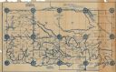
| Date: | 1877 |
|---|---|
| Description: | This map is a photstat copy of the original and shows landownership, townships and sections, wagon roads, railroads, school houses, churches, cemeteries, m... |
If you didn't find the material you searched for, our Library Reference Staff can help.
Call our reference desk at 608-264-6535 or email us at: