 Filter: Categories of Wisconsin Historical Images
Filter: Subject of Railroads
Filter: County of Brown
Filter: Categories of Wisconsin Historical Images
Filter: Subject of Railroads
Filter: County of Brown

| Date: | 1950 |
|---|---|
| Description: | This map shows portions of highway remaining unchanged, proposed relocations, connecting county trunk roads existing or proposed, existing arterials, and e... |

| Date: | 1914 |
|---|---|
| Description: | This map has relief shown by hachures and shows local streets, wards, districts, railroads, Fox River, and part of Bay of Green Bay. Wards are shown in dar... |
| Date: | 1935 |
|---|---|
| Description: | This map is a photocopy and shows landownership and acreages, additions to Green Bay, points of interest, roads, and railroads. Hand annotations of green,... |

| Date: | 1874 |
|---|---|
| Description: | This map shows streets, buildings, railroads, the Fox River, the East River, and part of Green Bay. |
| Date: | 01 1935 |
|---|---|
| Description: | This map shows landownership and acreages, additions to Green Bay, roads, railroads, East River, and Fox River. The bottom left of the map reads: "January ... |

| Date: | 1906 |
|---|---|
| Description: | This map shows streets, railroads, land use, public buildings, commercial businesses, and the Menominee River. Depths are shown by gradient tints and sound... |

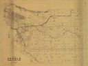
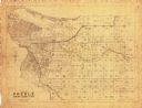
| Date: | 1900 |
|---|---|
| Description: | This map shows land owners, railroads, and rivers. |
If you didn't find the material you searched for, our Library Reference Staff can help.
Call our reference desk at 608-264-6535 or email us at: