 Filter: Categories of Wisconsin Historical Images
Filter: Subject of Railroads
Filter: Community of Stevens Point
Filter: Categories of Wisconsin Historical Images
Filter: Subject of Railroads
Filter: Community of Stevens Point

| Date: | 1891 |
|---|---|
| Description: | Bird's-eye map of Stevens Point, looking east, with an inset of the Water Works. Wisconsin River in foreground with fifty-three business locations identifi... |
| Date: | |
|---|---|
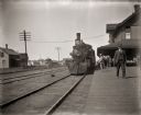
| Description: | View down platform towards locomotive and train at the railroad station. There are people standing on the platform near the depot building. |
| Date: | 1895 |
|---|---|
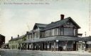
| Description: | View across railroad tracks towards the Wisconsin Central railroad station. Caption reads: "Soo Line Passenger Depot, Stevens Point, Wis." |
| Date: | 1915 |
|---|---|
| Description: | View across railroad tracks towards the Chicago, Milwaukee, & Sault Sainte Marie Railway Depot. In the background on the right is the Star Restaurant. Capt... |

| Date: | |
|---|---|
| Description: | Elevated view of the depot at the Southside Railroad Complex, which began operation in 1871. Adults and children stand near the railroad tracks outside of ... |

| Date: | 1986 |
|---|---|
| Description: | Pictorial map showing businesses with phone numbers, roads, railroads, and parks. Includes text titled: "History of Portage County." |

| Date: | 1922 |
|---|---|
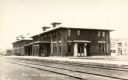
| Description: | Text on front reads: "Soo Line Depot, Stevens Point, Wis." The depot was built in 1918 of brick in the Prairie School style. There are pedestrians on the p... |

| Date: | 1891 |
|---|---|
| Description: | The index page of a Sanborn Map of Stevens Point. |
If you didn't find the material you searched for, our Library Reference Staff can help.
Call our reference desk at 608-264-6535 or email us at: