 Filter: Categories of Wisconsin Historical Images
Filter: Subject of Railroads
Filter: Community of Milwaukee
Filter: Subject of land use
Filter: Categories of Wisconsin Historical Images
Filter: Subject of Railroads
Filter: Community of Milwaukee
Filter: Subject of land use

| Date: | 1857 |
|---|---|
| Description: | From Judge Smith Addition, 5th Ward, looking north, toward the city. Drawing is an elevated view of field and plank fence in foreground, road to the left a... |
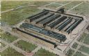
| Date: | 1910 |
|---|---|
| Description: | Aerial view of the factory surrounded by fields, roads, and several houses, as well as the railroad tracks that go around the building. Caption reads: "Wes... |

| Date: | 1943 |
|---|---|
| Description: | Elevated view of Wisconsin Avenue, looking east from Court of Honor. Caption reads: "Court of Honor, Looking East, Milwaukee, Wisconsin." |

| Date: | |
|---|---|
| Description: | An aerial view of downtown, including a baseball field in the lower left near a train station. |

| Date: | 1902 |
|---|---|
| Description: | This map is a chart of Milwaukee Harbor that displays local streets, bridges, roads, railroads, public buildings, businesses, factories, dry docks, parks, ... |

| Date: | 1872 |
|---|---|
| Description: | This map shows wards, roads, railroads, lot and block numbers, subdivisions, parks, some landownership, and a race course. Manuscript annotations in red in... |

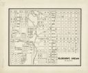
| Date: | 1880 |
|---|---|
| Description: | This map shows wards, roads, railroads, lot and block numbers, subdivisions, parks, and some landownership. A handwritten annotation in red reads: "Note: S... |
| Date: | 1940 |
|---|---|
| Description: | This map is pen and ink on paper and is map 7 in a series of 12. The map shows streets and a railroad line. |
| Date: | 1940 |
|---|---|
| Description: | This map is pen and ink on paper and is map 8 in a series of 12. The map shows streets and a railroad line. |

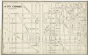
| Date: | 1880 |
|---|---|
| Description: | A map of Milwaukee which includes a city street guide. |
If you didn't find the material you searched for, our Library Reference Staff can help.
Call our reference desk at 608-264-6535 or email us at: