 Filter: Categories of Wisconsin Historical Images
Filter: Subject of Railroads
Filter: Community of Milwaukee
Filter: Subject of cities and towns
Filter: Year of 1900-1999
Filter: Categories of Wisconsin Historical Images
Filter: Subject of Railroads
Filter: Community of Milwaukee
Filter: Subject of cities and towns
Filter: Year of 1900-1999

| Date: | 1927 |
|---|---|
| Description: | Color map, hand-drawn with comic figures engaged in various activities throughout map. Bordered by the river on the left and Lake Michigan on the right, in... |
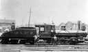
| Date: | 1903 |
|---|---|
| Description: | Chicago, Milwaukee and St. Paul railroad locomotive #1100, a class I engine, built by the Baldwin Locomotive Works in 1873 and originally numbered #199. Th... |

| Date: | 1908 |
|---|---|
| Description: | Colored map in perspective indicates railroad routes. Lake Winnebago and Oshkosh in center, area extends to Shawano (top right corner), Green Bay (bottom r... |
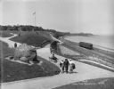
| Date: | 05 30 1914 |
|---|---|
| Description: | Juneau Park looking north from approximately E. Mason Street, with the Chicago and North Western railroad tracks on the right. The Lake Michigan shoreline ... |
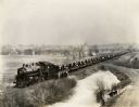
| Date: | 03 09 1927 |
|---|---|
| Description: | A train carrying tractors stopped on its way from Milwaukee Works (factory). |
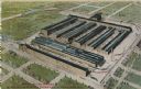
| Date: | 1910 |
|---|---|
| Description: | Aerial view of the factory surrounded by fields, roads, and several houses, as well as the railroad tracks that go around the building. Caption reads: "Wes... |
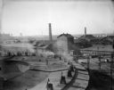
| Date: | 1940 |
|---|---|
| Description: | Located in West Milwaukee. View from atop a building of a large building located in the center, next to a smokestack. In the foreground is part of a round... |
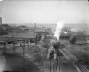
| Date: | 1940 |
|---|---|
| Description: | Located in West Milwaukee. Trains, cars, tracks, and railroad buildings. The view is taken from the top of a building. |
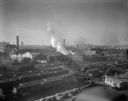
| Date: | 1940 |
|---|---|
| Description: | West Milwaukee. Elevated view of tracks, trains, and buildings. A train roundhouse is located in the background. |

| Date: | 1943 |
|---|---|
| Description: | Elevated view of Wisconsin Avenue, looking east from Court of Honor. Caption reads: "Court of Honor, Looking East, Milwaukee, Wisconsin." |

| Date: | 1915 |
|---|---|
| Description: | Elevated view of the Wells Street Viaduct. Caption reads: "Wells Street Viaduct, Milwaukee." |
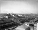
| Date: | 1940 |
|---|---|
| Description: | Elevated view of West Milwaukee shops of the Chicago, Milwaukee and St. Paul railroad. Railroad train cars are stopped on the tracks and smoke is rising fr... |

| Date: | 01 01 1940 |
|---|---|
| Description: | Engine #934 of the Chicago, Milwaukee, St. Paul and Pacific Railroad Company. |

| Date: | 1902 |
|---|---|
| Description: | A map of Milwaukee County, Wisconsin that shows the township and range system, sections, towns, roads, railroads and rail stations, cities and villages, po... |

| Date: | 1914 |
|---|---|
| Description: | A hand-drawn and colored map of the Milwaukee Township, showing how lands were used, included are parks, cemeteries, private grounds, and speculative land.... |

| Date: | 05 1958 |
|---|---|
| Description: | Photocopy of a map created by the City of Milwaukee Master Plan Program City Planning Division in May of 1958 representing 1870 "THE CENTRAL AREA OF THE CI... |

| Date: | 1906 |
|---|---|
| Description: | This map shows ward boundaries, lot and block numbers and dimensions, house numbers, electric car lines, steam railways, and adjoining plat numbers in a po... |

| Date: | 1900 |
|---|---|
| Description: | This map shows city wards, block numbers, parks, cemeteries, roads, railroads, Lake Michigan, and selected buildings. Also included are indexes "Milwaukee ... |

| Date: | 1901 |
|---|---|
| Description: | This map shows public schools, engine houses, railroads, street railways, city wards, parks, block numbers, and Lake Michigan. Also included are indexes, t... |

| Date: | 1902 |
|---|---|
| Description: | This map is a chart of Milwaukee Harbor that displays local streets, bridges, roads, railroads, public buildings, businesses, factories, dry docks, parks, ... |
If you didn't find the material you searched for, our Library Reference Staff can help.
Call our reference desk at 608-264-6535 or email us at: