 Filter: Categories of Wisconsin Historical Images
Filter: Subject of Railroads
Filter: Creator Name of Unknown
Filter: Categories of Wisconsin Historical Images
Filter: Subject of Railroads
Filter: Creator Name of Unknown

| Date: | 1930 |
|---|---|
| Description: | This map shows a plat of the town, local streets, railroads, creeks, part of Fox River, and part of the bay of Green Bay. The location of the original fort... |

| Date: | 1966 |
|---|---|
| Description: | The map shows streets, wells, school land, parks, cemeteries, railroads, and the Delbrook Golf Course. The bottom of the map reads: "January 11, 1962 May 2... |

| Date: | 1870 |
|---|---|
| Description: | This map is ink and color on tracing cloth and shows Iron Ridge, the hotel and saw mill at Iron Ridge Village, Milwaukee & St. Paul Railway, plank road, an... |
| Date: | 1966 |
|---|---|
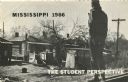
| Description: | View from behind of a man standing on railroad tracks surveying a row of dilapidated shanties. Used on the cover of brochure with the title, 'Mississippi 1... |
| Date: | |
|---|---|
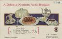
| Description: | Postcard menu from the Northern Pacific railroad line, with a plate filled with a steaming stack of pancakes topped with sausage links, a domed cover, a di... |
| Date: | 1934 |
|---|---|
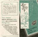
| Description: | Leaflet with sample menu and an illustration of a tall cold drink, behind which other dishes hold steaming hot food. The interior of the leaflet has an ill... |

| Date: | 1918 |
|---|---|
| Description: | This map has relief shown by hachures and is indexed by street name and buildings. The map shows plat of town, city limits, local streets, railroads, schoo... |
| Date: | 1967 |
|---|---|
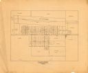
| Description: | This map is pen and pencil on paper and shows land ownership by name, blocks, lots, local streets, and railroads. To the right of the title the map reads: ... |

| Date: | |
|---|---|
| Description: | Buffet luncheon and drinks menu for the CMSP&P railway, with a waiter ready to serve a table of three men sitting at a table in the lounge car with drinks ... |

| Date: | 1924 |
|---|---|
| Description: | This map is pen, pencil, and watercolor on paper and shows land ownership by name, local streets, railroads, and part of Chequamegon Bay. The map includes ... |

| Date: | 1850 |
|---|---|
| Description: | This map shows a plat of the town, land owners by name, local streets, railroads, churches, and part of the Rock River. The map is also indexed by church d... |

| Date: | 1914 |
|---|---|
| Description: | This map has relief shown by hachures and shows local streets, wards, districts, railroads, Fox River, and part of Bay of Green Bay. Wards are shown in dar... |

| Date: | 1960 |
|---|---|
| Description: | This map shows lot numbers and dimensions, railroad, and streets. Fall Creek and Mill Pond (now Fall Creek Pond) are labeled. The map is a blue line print. |

| Date: | 1891 |
|---|---|
| Description: | This colorful map shows additions, railroads, docks, streets, established dock lines, marshes, and proposed belt line railroad. The map covers west and sou... |

| Date: | 1903 |
|---|---|
| Description: | Railroad pass for the Hillsboro and North Eastern Railroad. A short track spanning from Hillsboro to Union Center, the Railroad was in operation from 1903 ... |

| Date: | 1838 |
|---|---|
| Description: | A color map of the settled part of Wisconsin Territory in 1838, including an inset map of the "Entire Territory of Wisconsin as Established by Act of Congr... |

| Date: | 1911 |
|---|---|
| Description: | A plat map of the township of Westport in Dane County. |
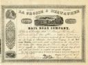
| Date: | 1857 |
|---|---|
| Description: | Engraved document certifying that D. Henry Rockwell of Oconomowoc is entitled to one share of the La Crosse and Milwaukee Rail Road Company worth one hundr... |

| Date: | 02 17 1913 |
|---|---|
| Description: | Cyanotype menu for a Railroad Commission Dinner Dance, with a train steaming down the tracks, the seal of the state of Wisconsin, and two presentations of ... |
If you didn't find the material you searched for, our Library Reference Staff can help.
Call our reference desk at 608-264-6535 or email us at:
