 Filter: Categories of Wisconsin Historical Images
Filter: Subject of Railroads
Filter: Creator Name of Unknown
Filter: Year of 1900-1999
Filter: Year of 1920-1929
Filter: Categories of Wisconsin Historical Images
Filter: Subject of Railroads
Filter: Creator Name of Unknown
Filter: Year of 1900-1999
Filter: Year of 1920-1929
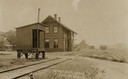
| Date: | 1923 |
|---|---|
| Description: | Railway depot and railyard. Caption reads: "Depot and Yards Fitchburg, Wis." |

| Date: | 1920 |
|---|---|
| Description: | Caption reads: "Mammoth Ore Docks, Ashland, Wis." A building and roads are in the foreground. Several ore ships can be seen. |
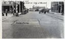
| Date: | 1925 |
|---|---|
| Description: | View of the railroad crossing where rubber paving was used for the first time in the United States. Caption at top reads: "First Rubber Crossing in U.S. S.... |
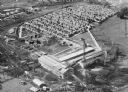
| Date: | 1920 |
|---|---|
| Description: | Aerial view of the Baldwin Lumber Company, which sits next to a river. The main building consists of two long, rectangular structures that sit perpendicula... |

| Date: | 1920 |
|---|---|
| Description: | Elevated view of Massillon Iron and Steel Works, which rolled its first sheet of steel in 1909. Caption reads: "Massillon Iron & Steel Co., Massillon, Ohio... |
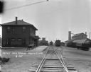
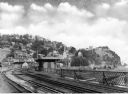
| Date: | 1925 |
|---|---|
| Description: | View down railroad tracks of a locomotive pulling into a railroad depot and yards. The depot is a two-story building. Two wagons are parked near the depot ... |
| Date: | 1925 |
|---|---|
| Description: | View from the Baltimore and Ohio Railroad Station, established in 1830. The city's dwellings and establishments can be seen on a hillside from the railroa... |

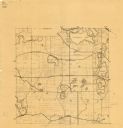
| Date: | 1928 |
|---|---|
| Description: | Map of portions of Wisconsin and Minnesota between Lake Superior and Mississippi River, showing railroads and military road. |

| Date: | 1926 |
|---|---|
| Description: | This Wisconsin Conservation Commission map from the 1920s shows roads, railroads, campsites, lookout towers, and privately owned lands in Northern Forest S... |

| Date: | 1920 |
|---|---|
| Description: | This map shows the township and range system, sections, schools, churches, cemeteries, town halls, roads, railroads, and lakes and streams in Shawano Count... |

| Date: | 1920 |
|---|---|
| Description: | This manuscript map of southern Bayfield County, Wisconsin, covers the towns of Cable and Drummond and portions of Grandview and Namekagon. Shown are the t... |

| Date: | 1923 |
|---|---|
| Description: | This topographical map of Devil's Lake State Park, Sauk County, Wisconsin, is based on 1922-1923 surveys of the area by the University of Wisconsin Summer ... |

| Date: | 1928 |
|---|---|
| Description: | Shows different types of roads, railroads, schools, churches, farmsteads, cheese factories, mine shafts, old surface workings, streams, old sulphur pits, a... |

| Date: | 1928 |
|---|---|
| Description: | Illustrated map of points of interest, including University buildings, parks, athletic venues, fraternity and sorority houses, and state buildings. |

| Date: | 1920 |
|---|---|
| Description: | Map shows townships and sections, landownership and acreages, roads, and railroads in southwest portion of Marinette County. Sections of the map are in ye... |
| Date: | 1925 |
|---|---|
| Description: | This map shows township sections, roads, railroads, and lakes. The map also features extensive manuscript annotations noting landownership in pencil. Stamp... |

| Date: | 1924 |
|---|---|
| Description: | This map is pen, pencil, and watercolor on paper and shows land ownership by name, local streets, railroads, and part of Chequamegon Bay. The map includes ... |

| Date: | 1920 |
|---|---|
| Description: | This blue print map and blue line print copy mounted on cloth shows land ownership by name, campus buildings, local streets, railroads, and part of Lake Me... |
If you didn't find the material you searched for, our Library Reference Staff can help.
Call our reference desk at 608-264-6535 or email us at:

