Filter: Categories of Wisconsin Historical Images
Filter: Subject of Railroads
Filter: Creator Name of Unknown
Filter: Year of 1900-1999
Filter: Subject of roads
Filter: Categories of Wisconsin Historical Images
Filter: Subject of Railroads
Filter: Creator Name of Unknown
Filter: Year of 1900-1999
Filter: Subject of roads

| Date: | 1930 |
|---|---|
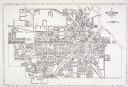
| Description: | Aerial view of the city and the river. |

| Date: | 1920 |
|---|---|
| Description: | Caption reads: "Mammoth Ore Docks, Ashland, Wis." A building and roads are in the foreground. Several ore ships can be seen. |

| Date: | 1916 |
|---|---|
| Description: | Southeastern Wisconsin which lies east of Whitewater and south of Port Washington. |

| Date: | 1915 |
|---|---|
| Description: | Plat map of Polk township in Washington County. |

| Date: | 1918 |
|---|---|
| Description: | The West Madison Chicago, Milwaukee, and St. Paul railroad station, with train cars on the tracks. |

| Date: | 1911 |
|---|---|
| Description: | A map of the village of Black Earth and Verona. |
| Date: | 1920 |
|---|---|
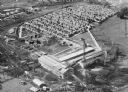
| Description: | Aerial view of the Baldwin Lumber Company, which sits next to a river. The main building consists of two long, rectangular structures that sit perpendicula... |

| Date: | 1920 |
|---|---|
| Description: | Elevated view of Massillon Iron and Steel Works, which rolled its first sheet of steel in 1909. Caption reads: "Massillon Iron & Steel Co., Massillon, Ohio... |

| Date: | 1931 |
|---|---|
| Description: | A map of the village of Verona, Wisconsin. |

| Date: | 1902 |
|---|---|
| Description: | Two panoramic bird's-eye views of the Paine Lumber Company, including the general plant, sawmill, and lumber yards. Heading at the top says: Home of Wiscon... |
| Date: | 1925 |
|---|---|
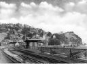
| Description: | View from the Baltimore and Ohio Railroad Station, established in 1830. The city's dwellings and establishments can be seen on a hillside from the railroa... |

| Date: | 1938 |
|---|---|
| Description: | This map shows lakes, rivers, roads, trails, lookout towers, and railroads. |

| Date: | 1928 |
|---|---|
| Description: | Map of portions of Wisconsin and Minnesota between Lake Superior and Mississippi River, showing railroads and military road. |

| Date: | 1900 |
|---|---|
| Description: | A map of Wisconsin, eastern Minnesota and Iowa, northern Iowa, and Michigan’s Upper Peninsula, showing railway lines, with those marked with heavy red line... |

| Date: | 1975 |
|---|---|
| Description: | This map shows the locations of historic sites and points of interest in Rusk County, Wisconsin. A location key, descriptions of the historical importance ... |

| Date: | 1946 |
|---|---|
| Description: | Map of Kewaunee County, Wisconsin, shows towns, cities and villages, roads and highways, railroads, schools, lighthouses, place names, town divisions, comm... |
If you didn't find the material you searched for, our Library Reference Staff can help.
Call our reference desk at 608-264-6535 or email us at: