Filter: Categories of Wisconsin Historical Images
Filter: Subject of Railroads
Filter: Creator Name of Unknown
Filter: Subject of water
Filter: Year of 1900-1999
Filter: Categories of Wisconsin Historical Images
Filter: Subject of Railroads
Filter: Creator Name of Unknown
Filter: Subject of water
Filter: Year of 1900-1999
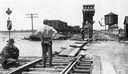
| Date: | 1915 |
|---|---|
| Description: | Four men inspecting the washout of Minneapolis, St. Paul and Sault Ste. Marie tracks caused by a flood at Medina Junction. The view is looking west from th... |

| Date: | 1930 |
|---|---|
| Description: | Aerial view of the city and the river. |

| Date: | 1920 |
|---|---|
| Description: | Caption reads: "Mammoth Ore Docks, Ashland, Wis." A building and roads are in the foreground. Several ore ships can be seen. |
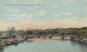
| Date: | 1905 |
|---|---|
| Description: | Elevated view of the river, with railroad tracks on the left shoreline, and a railroad bridge crossing the river. Caption reads: "View of River from Grand ... |

| Date: | 1911 |
|---|---|
| Description: | Plat Map of Blooming Grove in "Atlas of Dane County, Wisconsin." |

| Date: | 1915 |
|---|---|
| Description: | Elevated view of the St. Croix River, Northwest Railroad, bridge, and part of the town of Hudson. Caption reads: "Hudson, Wis. Bird's Eye View, showing St.... |

| Date: | 1940 |
|---|---|
| Description: | Aerial view of the bridge spanning the Mississippi River in La Crosse. |

| Date: | 1911 |
|---|---|
| Description: | Elevated view of the John Gund Brewing Company buildings, with the Mississippi River in the background. Caption reads: "John Gund Brewing Co., La Crosse, W... |

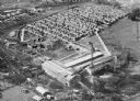
| Date: | 1935 |
|---|---|
| Description: | An aerial view of numerous Manitowoc factories/industries. |

| Date: | 1916 |
|---|---|
| Description: | Southeastern Wisconsin which lies east of Whitewater and south of Port Washington. |

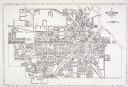
| Date: | 1915 |
|---|---|
| Description: | Advertisement reads: "Castle-Pierce Printing Company" and "Feb. 1915". Text on right reads: "The Heart of Oshkosh. This birds-eye view represents about one... |

| Date: | 1915 |
|---|---|
| Description: | Plat map of Polk township in Washington County. |
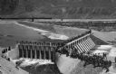
| Date: | 1903 |
|---|---|
| Description: | Elevated view of Derby Diversion Dam with a crowd gathered on the rim of the dam and individuals standing along its top. A train cuts across the horizon in... |

| Date: | 1911 |
|---|---|
| Description: | A map of the village of Black Earth and Verona. |
| Date: | 1920 |
|---|---|
| Description: | Aerial view of the Baldwin Lumber Company, which sits next to a river. The main building consists of two long, rectangular structures that sit perpendicula... |

| Date: | 1931 |
|---|---|
| Description: | A map of the village of Verona, Wisconsin. |
If you didn't find the material you searched for, our Library Reference Staff can help.
Call our reference desk at 608-264-6535 or email us at: