 Filter: Categories of Wisconsin Historical Images
Filter: Subject of Railroads
Filter: Creator Name of Unknown
Filter: Subject of water
Filter: Categories of Wisconsin Historical Images
Filter: Subject of Railroads
Filter: Creator Name of Unknown
Filter: Subject of water

| Date: | |
|---|---|
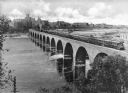
| Description: | View from hill towards the elevated Chicago, St. Paul, Minneapolis and Omaha railroad bridge over the Chippewa River at Eau Claire. |

| Date: | 1915 |
|---|---|
| Description: | Advertisement reads: "Castle-Pierce Printing Company" and "Feb. 1915". Text on right reads: "The Heart of Oshkosh. This birds-eye view represents about one... |

| Date: | 1872 |
|---|---|
| Description: | Map entitled Office Wallbridge Bro. U. Sargent showing upper Minnesota and Wisconsin, as well as Lake Superior. |

| Date: | 1915 |
|---|---|
| Description: | Plat map of Polk township in Washington County. |

| Date: | |
|---|---|
| Description: | Commemorative Civil War roster of First Regiment Wisconsin Volunteer Cavalry, Wisconsin Hussars Squadron "G." Depicts "Our Country as it was in 1860" with ... |

| Date: | 1878 |
|---|---|
| Description: | View from riverbank of the Chicago Milwaukee and St. Paul railroad locomotive no. 142 on the Kilbourn bridge. |
| Date: | 1899 |
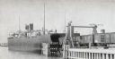
|---|---|
| Description: | Chicago, St. Paul, Minneapolis & Omaha train cars loading onto car ferry Pere Marquette. |

| Date: | 1882 |
|---|---|
| Description: | The official railroad map of Wisconsin showing railroad lines throughout the state. |

| Date: | 1884 |
|---|---|
| Description: | The official railroad map of Wisconsin showing railroad lines throughout the state. |

| Date: | |
|---|---|
| Description: | View of the Burlington Northern Santa Fe Railroad Bridge spanning the Columbia River, connecting Vancouver, Washington, with Portland, Oregon. Caption read... |

| Date: | |
|---|---|
| Description: | Elevated view of the camp and valley of the site of the Elephant Butte Dam near Truth or Consequences. There are buildings, roads, railroad tracks, and tra... |
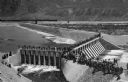
| Date: | 1903 |
|---|---|
| Description: | Elevated view of Derby Diversion Dam with a crowd gathered on the rim of the dam and individuals standing along its top. A train cuts across the horizon in... |

| Date: | |
|---|---|
| Description: | View of Rock Island Pond, with a telephone pole in the foreground, and railroad tracks leading off into the distance. In the distance is a farm or manufact... |
| Date: | |
|---|---|
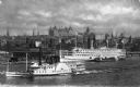
| Description: | Elevated view of the two steamships, including the James T. Brett, on the Hudson River, with the central business district of the city in the background. |
| Date: | |
|---|---|
| Description: | Elevated view of an Oriental Limited train crossing The Stone Arch Bridge over a river. The bridge was built by The Great Northern Railway in 1883. There i... |

| Date: | |
|---|---|
| Description: | Elevated distant view of the town of Medicine Hat, Alberta and a Canadian Pacific Railway Bridge. Caption reads: "General View of Medicine Hat, Alta. Showi... |

| Date: | |
|---|---|
| Description: | Elevated view of the city, which includes a factory, numerous buildings, railroad tracks, a bridge, Elizabeth river, and hills in the background. |

| Date: | 1856 |
|---|---|
| Description: | A Wisconsin map showing the Wisconsin Superior and St. Croix Railroad. |
If you didn't find the material you searched for, our Library Reference Staff can help.
Call our reference desk at 608-264-6535 or email us at:

