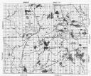
| Date: | 1969 |
|---|---|
| Description: | A map of the Elroy-Sparta State Trail and the surrounding area, showing the townships, the towns of Cashton, Sparta, in the west, and Union Center and Elro... |

| Date: | 1898 |
|---|---|
| Description: | This 1896 map of the Chain-O-Lakes region of Waupaca County, Wisconsin, shows the lakes and streams, some topography, archaeological sites, roads, railroad... |

| Date: | 1860 |
|---|---|
| Description: | This map shows roads, trails, and railroads throughout Nebraska, Arkansas, Missouri, Kansas, Illinois, and Utah, including the Salt Lake City & California ... |

| Date: | 1952 |
|---|---|
| Description: | This map shows roads, foot and canoe trails, railroads, resorts, lookout towers, camps, national and state forests, Indian reservation, and types of fish i... |

| Date: | 1900 |
|---|---|
| Description: | This map shows logging roads, railroads with spur lines, trails, rapids, lumber camps, Indian villages, summer resort, lakes, rivers, and ponds. |
If you didn't find the material you searched for, our Library Reference Staff can help.
Call our reference desk at 608-264-6535 or email us at: