Filter: Categories of Wisconsin Historical Images
Filter: Subject of Railroads
Filter: Creator Name of Unknown
Filter: Subject of streets
Filter: Categories of Wisconsin Historical Images
Filter: Subject of Railroads
Filter: Creator Name of Unknown
Filter: Subject of streets

| Date: | 2007 |
|---|---|
| Description: | This map of Cedarbug is a bird's-eye map with 8 inset views and an index. The map is a print out of the original map dated 1892 held at the Cedarburg Cultu... |

| Date: | 1874 |
|---|---|
| Description: | Bird's-eye map of Chippewa Falls. |

| Date: | 1881 |
|---|---|
| Description: | Bird's-eye map of Milton Junction. |

| Date: | 1879 |
|---|---|
| Description: | This map is a bird's-eye view of Wausau, the County Seat of Marathon County. The map features an index of points of interest. |
| Date: | 1910 |
|---|---|
| Description: | The Chicago & Northwestern Railway passenger depot. Caption reads: "C. & N. W. Passenger Depot, Madison, Wis." |

| Date: | 1911 |
|---|---|
| Description: | Elevated view of the John Gund Brewing Company buildings, with the Mississippi River in the background. Caption reads: "John Gund Brewing Co., La Crosse, W... |
| Date: | 1925 |
|---|---|
| Description: | View of the railroad crossing where rubber paving was used for the first time in the United States. Caption at top reads: "First Rubber Crossing in U.S. S.... |

| Date: | |
|---|---|
| Description: | Plat map of the east central part of the city. |

| Date: | 1943 |
|---|---|
| Description: | Elevated view of Wisconsin Avenue, looking east from Court of Honor. Caption reads: "Court of Honor, Looking East, Milwaukee, Wisconsin." |

| Date: | |
|---|---|
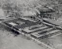
| Description: | Elevated view of city, including miners' homes set in the hills, and in the foreground railroad tracks and numerous cars parked along the street in front o... |
| Date: | |
|---|---|
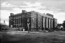
| Description: | View across intersection toward a brick auditorium building. A man sits on the steps of the main entrance while others walk on the sidewalk. Three men in c... |
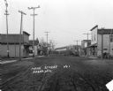
| Date: | 1913 |
|---|---|
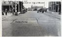
| Description: | View down of Main Street, which is a dirt street passing through the central business district of the town, featuring several storefronts with porches and ... |

| Date: | 10 24 1946 |
|---|---|
| Description: | Photographic postcard of an aerial view of town. Text below reads: "Aerial View — Boscobel, Wis." |
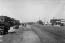
| Date: | 1910 |
|---|---|
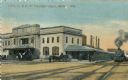
| Description: | Commercial buildings stand on either side of a set of railroad tracks. Automobiles line each street and the Toombs County Courthouse, featuring a colonnad... |

| Date: | 1892 |
|---|---|
| Description: | Topographical map of Madison and surrounding communities which include Lake Mendota, Lake Monona, Lake Waubesa and Lake Kegonsa. The red dots on the map sh... |

| Date: | |
|---|---|
| Description: | Letterhead of the Chilton Branch of the Falk Jung & Borchert Brewing Company, headquartered in Milwaukee, Wisconsin. It includes, on the left, an elevated ... |

| Date: | |
|---|---|
| Description: | Letterhead of the John Gund Brewing Company of La Crosse, Wisconsin, with an elevated view of the brewery complex on the left. On the right is the company ... |

| Date: | |
|---|---|
| Description: | Memohead of the Joseph Schlitz Brewing Company of Milwaukee, Wisconsin, with an elevated view of the brewery complex, including an elevator and other stora... |

| Date: | |
|---|---|
| Description: | Letterhead of the Phillip Best Brewing Company of Milwaukee, Wisconsin, with three separate proscenium views of the Empire Brewery, the South Side Brewery,... |
If you didn't find the material you searched for, our Library Reference Staff can help.
Call our reference desk at 608-264-6535 or email us at: