 Filter: Categories of Wisconsin Historical Images
Filter: Subject of Railroads
Filter: Creator Name of Unknown
Filter: Subject of land
Filter: Categories of Wisconsin Historical Images
Filter: Subject of Railroads
Filter: Creator Name of Unknown
Filter: Subject of land

| Date: | 1930 |
|---|---|
| Description: | Map of Ripon, Wisconsin. In the lower left hand corner is a list of points of interest that correspond with numbers on the map. Streets and Mill Pond are l... |
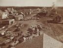
| Date: | 09 1902 |
|---|---|
| Description: | Elevated view of farmers with horse-drawn wagons waiting to ship their harvest goods, probably potatoes, at an unidentified town. There are railroad tracks... |

| Date: | 1900 |
|---|---|
| Description: | This map of Three Lakes shows forest fire lookout towers, picnic grounds, an airport, roads, and railroad. The map features text boxes on the Village of Th... |

| Date: | 1890 |
|---|---|
| Description: | This is a plat map of "Wauzeeka" drawn in pencil. The map shows numbered lots, labeled streets, the Kickapoo River, and railroads. The map reads: "Laid out... |

| Date: | 1900 |
|---|---|
| Description: | This map of Bangor is ink and pencil on cloth. The map shows roads, railroads, residences, mills, the original plat of Bangor, and the Wisconsin and Wheldo... |

| Date: | 1856 |
|---|---|
| Description: | This map of Brohead shows land and lot ownerships by name and color, as well as roads, and railroads. |

| Date: | 1840 |
|---|---|
| Description: | This map of Kewaunee shows lot and block numbers, Lake Michigan, and includes a location map showing proposed railroads. The map includes manuscript annota... |

| Date: | 1893 |
|---|---|
| Description: | This map of La Crosse shows wards 1-20, streets, railroads, the Inter State Fair Grounds, islands, and the Mississippi River. Relief is shown by hachures. ... |

| Date: | 1881 |
|---|---|
| Description: | Bird's-eye view of Milwaukee from the south lakeshore. |

| Date: | 1900 |
|---|---|
| Description: | The map is watercolor, pencil, and ink on tracing cloth and shows plats of both cities, local streets, railroads, mills, township divisions, bridges, and p... |

| Date: | 1930 |
|---|---|
| Description: | This map has relief shown pictorially and shows plat of the city, block numbers, land ownership by name, local streets, railroads, mill pond, and part of G... |
| Date: | 1925 |
|---|---|
| Description: | This map shows township sections, roads, railroads, and lakes. The map also features extensive manuscript annotations noting landownership in pencil. Stamp... |

| Date: | 1930 |
|---|---|
| Description: | This map shows a plat of the town, local streets, railroads, creeks, part of Fox River, and part of the bay of Green Bay. The location of the original fort... |

| Date: | 1870 |
|---|---|
| Description: | This map is ink and color on tracing cloth and shows Iron Ridge, the hotel and saw mill at Iron Ridge Village, Milwaukee & St. Paul Railway, plank road, an... |

| Date: | 1918 |
|---|---|
| Description: | This map has relief shown by hachures and is indexed by street name and buildings. The map shows plat of town, city limits, local streets, railroads, schoo... |

| Date: | 1924 |
|---|---|
| Description: | This map is pen, pencil, and watercolor on paper and shows land ownership by name, local streets, railroads, and part of Chequamegon Bay. The map includes ... |

| Date: | 1850 |
|---|---|
| Description: | This map shows a plat of the town, land owners by name, local streets, railroads, churches, and part of the Rock River. The map is also indexed by church d... |

| Date: | 1914 |
|---|---|
| Description: | This map has relief shown by hachures and shows local streets, wards, districts, railroads, Fox River, and part of Bay of Green Bay. Wards are shown in dar... |

| Date: | 1960 |
|---|---|
| Description: | This map shows lot numbers and dimensions, railroad, and streets. Fall Creek and Mill Pond (now Fall Creek Pond) are labeled. The map is a blue line print. |

| Date: | 1891 |
|---|---|
| Description: | This colorful map shows additions, railroads, docks, streets, established dock lines, marshes, and proposed belt line railroad. The map covers west and sou... |
If you didn't find the material you searched for, our Library Reference Staff can help.
Call our reference desk at 608-264-6535 or email us at: