 Filter: Categories of Wisconsin Historical Images
Filter: Subject of Railroads
Filter: Creator Name of Unknown
Filter: Subject of land
Filter: Subject of roads
Filter: Categories of Wisconsin Historical Images
Filter: Subject of Railroads
Filter: Creator Name of Unknown
Filter: Subject of land
Filter: Subject of roads
| Date: | |
|---|---|
| Description: | Elevated view from hill of the road between the railroad and the Mescalero Agency, which is surrounded by a sixty by twenty mile section of white sands, co... |

| Date: | 1911 |
|---|---|
| Description: | Plat Map of Blooming Grove in "Atlas of Dane County, Wisconsin." |

| Date: | 1916 |
|---|---|
| Description: | Southeastern Wisconsin which lies east of Whitewater and south of Port Washington. |

| Date: | 1915 |
|---|---|
| Description: | Plat map of Polk township in Washington County. |

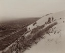
| Date: | |
|---|---|
| Description: | Elevated view of the camp and valley of the site of the Elephant Butte Dam near Truth or Consequences. There are buildings, roads, railroad tracks, and tra... |

| Date: | 1911 |
|---|---|
| Description: | A map of the village of Black Earth and Verona. |

| Date: | 1931 |
|---|---|
| Description: | A map of the village of Verona, Wisconsin. |
| Date: | 1925 |
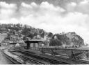
|---|---|
| Description: | View from the Baltimore and Ohio Railroad Station, established in 1830. The city's dwellings and establishments can be seen on a hillside from the railroa... |
| Date: | |
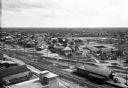
|---|---|
| Description: | Elevated view of town buildings with railroad tracks running through the town. A railroad depot stands in the foreground. |

| Date: | |
|---|---|
| Description: | Letterhead of the Kewaskum Mutual Fire Insurance Company of Washington County, Wisconsin, with a Native American man wearing buckskin clothes and leggings ... |

| Date: | 1928 |
|---|---|
| Description: | Map of portions of Wisconsin and Minnesota between Lake Superior and Mississippi River, showing railroads and military road. |

| Date: | 1900 |
|---|---|
| Description: | A map of Wisconsin, eastern Minnesota and Iowa, northern Iowa, and Michigan’s Upper Peninsula, showing railway lines, with those marked with heavy red line... |

| Date: | 1860 |
|---|---|
| Description: | A hand-drawn, ink on cloth map of southeastern Wisconsin that show roads and railroads that connect Chicago to Milwaukee and other towns in the southeaster... |

| Date: | 1975 |
|---|---|
| Description: | This map shows the locations of historic sites and points of interest in Rusk County, Wisconsin. A location key, descriptions of the historical importance ... |

| Date: | 1894 |
|---|---|
| Description: | A detail of a Wisconsin map showing Sawyer, Chippewa and Price counties. |
If you didn't find the material you searched for, our Library Reference Staff can help.
Call our reference desk at 608-264-6535 or email us at:


