Filter: Categories of Wisconsin Historical Images
Filter: Subject of Railroads
Filter: Creator Name of Unknown
Filter: Subject of land
Filter: Categories of Wisconsin Historical Images
Filter: Subject of Railroads
Filter: Creator Name of Unknown
Filter: Subject of land

| Date: | 1874 |
|---|---|
| Description: | Bird's-eye map of Chippewa Falls. |

| Date: | 1879 |
|---|---|
| Description: | This map is a bird's-eye view of Wausau, the County Seat of Marathon County. The map features an index of points of interest. |
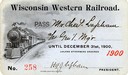
| Date: | 1900 |
|---|---|
| Description: | Pass # 258 issued to General Manager Charles Lapham by the Wisconsin Western Railroad for the year 1900. |
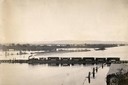
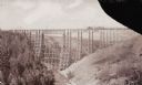
| Date: | |
|---|---|
| Description: | Elevated view of the pile-pontoon railroad bridge across the Mississippi River at Prairie du Chien. The bridge was built and patented by John Lawler in 187... |

| Date: | 1890 |
|---|---|
| Description: | View looking down railroad tracks towards the Chicago, Milwaukee and St. Paul Railroad locomotive #240, a type 4-4-0. On the right is a steep, rocky bank, ... |
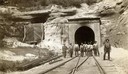
| Date: | |
|---|---|
| Description: | View down railroad tracks towards a group of construction workers posed near the east portal of the railroad tunnel near Tunnel City. |
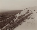
| Date: | |
|---|---|
| Description: | Elevated view from hill of the road between the railroad and the Mescalero Agency, which is surrounded by a sixty by twenty mile section of white sands, co... |
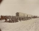
| Date: | 10 1898 |
|---|---|
| Description: | A cavalry troop from the Ojibwa-Pillager Battle at Sugar Point on Bear Island gathers near a train. |
| Date: | |
|---|---|
| Description: | Two Medicine Bridge, part of the Gulf and Northern Railroad. |
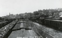
| Date: | 1907 |
|---|---|
| Description: | Elevated view above railroad cars towards downtown Elroy. Caption reads: "Partial View Elroy Wis." |

| Date: | 1911 |
|---|---|
| Description: | Plat Map of Blooming Grove in "Atlas of Dane County, Wisconsin." |

| Date: | 1915 |
|---|---|
| Description: | Elevated view of the St. Croix River, Northwest Railroad, bridge, and part of the town of Hudson. Caption reads: "Hudson, Wis. Bird's Eye View, showing St.... |

| Date: | |
|---|---|
| Description: | Plat map of the east central part of the city. |

| Date: | 1916 |
|---|---|
| Description: | Southeastern Wisconsin which lies east of Whitewater and south of Port Washington. |
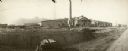
| Date: | |
|---|---|
| Description: | Shops under construction for the Chicago, St. Paul, Minneapolis, and Omaha railroad lines. Men are working with a horse-drawn wagon in the right foreground... |

| Date: | |
|---|---|
| Description: | View from hill towards the elevated Chicago, St. Paul, Minneapolis and Omaha railroad bridge over the Chippewa River at Eau Claire. |

| Date: | 1872 |
|---|---|
| Description: | Map entitled Office Wallbridge Bro. U. Sargent showing upper Minnesota and Wisconsin, as well as Lake Superior. |
If you didn't find the material you searched for, our Library Reference Staff can help.
Call our reference desk at 608-264-6535 or email us at: