 Filter: Categories of Wisconsin Historical Images
Filter: Subject of Railroads
Filter: Creator Name of Unknown
Filter: Subject of human settlements
Filter: Categories of Wisconsin Historical Images
Filter: Subject of Railroads
Filter: Creator Name of Unknown
Filter: Subject of human settlements

| Date: | 1932 |
|---|---|
| Description: | This map of Beaver Dam shows new boundary lines for wards, existing wards, roads, railroads, and rivers. Roads and Beaver Dam Lake are labeled. There are s... |

| Date: | 1856 |
|---|---|
| Description: | This map of Brohead shows land and lot ownerships by name and color, as well as roads, and railroads. |

| Date: | 1950 |
|---|---|
| Description: | Aerial view showing shipyards, rivers and roads. |

| Date: | 1840 |
|---|---|
| Description: | This map of Kewaunee shows lot and block numbers, Lake Michigan, and includes a location map showing proposed railroads. The map includes manuscript annota... |

| Date: | 1900 |
|---|---|
| Description: | This map of La Crosse shows twenty wards, some rural lots with acreages, streets, railroads, depots, bridges, cemeteries, parks, schools, islands, and the ... |

| Date: | 1880 |
|---|---|
| Description: | This map of the southern part of La Crosse is pen on cloth and shows proposed streets crossing the lands of Jane Usher and the Green Bay, Winona and St. Pa... |

| Date: | 1881 |
|---|---|
| Description: | Bird's-eye view of Milwaukee from the south lakeshore. |
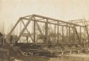
| Date: | 1906 |
|---|---|
| Description: | Steel span railroad bridge under construction over Cedar Creek. |

| Date: | 1900 |
|---|---|
| Description: | The map is watercolor, pencil, and ink on tracing cloth and shows plats of both cities, local streets, railroads, mills, township divisions, bridges, and p... |

| Date: | 1930 |
|---|---|
| Description: | This map has relief shown pictorially and shows plat of the city, block numbers, land ownership by name, local streets, railroads, mill pond, and part of G... |
| Date: | 1925 |
|---|---|
| Description: | This map shows township sections, roads, railroads, and lakes. The map also features extensive manuscript annotations noting landownership in pencil. Stamp... |

| Date: | 1930 |
|---|---|
| Description: | This map shows a plat of the town, local streets, railroads, creeks, part of Fox River, and part of the bay of Green Bay. The location of the original fort... |

| Date: | 1966 |
|---|---|
| Description: | The map shows streets, wells, school land, parks, cemeteries, railroads, and the Delbrook Golf Course. The bottom of the map reads: "January 11, 1962 May 2... |

| Date: | 1918 |
|---|---|
| Description: | This map has relief shown by hachures and is indexed by street name and buildings. The map shows plat of town, city limits, local streets, railroads, schoo... |
| Date: | 1967 |
|---|---|
| Description: | This map is pen and pencil on paper and shows land ownership by name, blocks, lots, local streets, and railroads. To the right of the title the map reads: ... |

| Date: | 1850 |
|---|---|
| Description: | This map shows a plat of the town, land owners by name, local streets, railroads, churches, and part of the Rock River. The map is also indexed by church d... |

| Date: | 1914 |
|---|---|
| Description: | This map has relief shown by hachures and shows local streets, wards, districts, railroads, Fox River, and part of Bay of Green Bay. Wards are shown in dar... |

| Date: | 1960 |
|---|---|
| Description: | This map shows lot numbers and dimensions, railroad, and streets. Fall Creek and Mill Pond (now Fall Creek Pond) are labeled. The map is a blue line print. |

| Date: | 1838 |
|---|---|
| Description: | A color map of the settled part of Wisconsin Territory in 1838, including an inset map of the "Entire Territory of Wisconsin as Established by Act of Congr... |
If you didn't find the material you searched for, our Library Reference Staff can help.
Call our reference desk at 608-264-6535 or email us at:
