Filter: Categories of Wisconsin Historical Images
Filter: Subject of Railroads
Filter: Creator Name of Unknown
Filter: Subject of cities and towns
Filter: Subject of roads
Filter: Categories of Wisconsin Historical Images
Filter: Subject of Railroads
Filter: Creator Name of Unknown
Filter: Subject of cities and towns
Filter: Subject of roads

| Date: | 1876 |
|---|---|
| Description: | Bird's-eye view of Middleton with an inset of a school house. |

| Date: | 1874 |
|---|---|
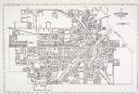
| Description: | Bird's-eye map of Lodi, with inset of Public School. Includes index of churches and points of interest. |

| Date: | 1930 |
|---|---|
| Description: | Aerial view of the city and the river. |

| Date: | 1920 |
|---|---|
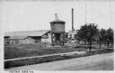
| Description: | Caption reads: "Mammoth Ore Docks, Ashland, Wis." A building and roads are in the foreground. Several ore ships can be seen. |

| Date: | 1911 |
|---|---|
| Description: | Plat Map of Blooming Grove in "Atlas of Dane County, Wisconsin." |
| Date: | |
|---|---|
| Description: | View across road toward buildings, including a water tower. Caption reads: "Frog Shop, Tomah, Wis." |
| Date: | 1886 |
|---|---|
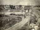
| Description: | View of the Chicago, Burlington, and Quincy railroad drawbridge and trestle. |

| Date: | 1916 |
|---|---|
| Description: | Southeastern Wisconsin which lies east of Whitewater and south of Port Washington. |

| Date: | 1915 |
|---|---|
| Description: | Plat map of Polk township in Washington County. |

| Date: | 1918 |
|---|---|
| Description: | The West Madison Chicago, Milwaukee, and St. Paul railroad station, with train cars on the tracks. |

| Date: | |
|---|---|
| Description: | The Atlantic Coastline Railroad Station was formed on July 18, 1898 as a consolidation of the Wilmington, Columbia and Augusta Railroad and Northeastern Ra... |

| Date: | 1911 |
|---|---|
| Description: | A map of the village of Black Earth and Verona. |

| Date: | 1931 |
|---|---|
| Description: | A map of the village of Verona, Wisconsin. |
| Date: | 1880 |
|---|---|
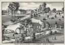
| Description: | An illustration depicting the cheese factory and dry goods store of J.G. Pickett at Pickett's Station. |
If you didn't find the material you searched for, our Library Reference Staff can help.
Call our reference desk at 608-264-6535 or email us at: