 Filter: Categories of Wisconsin Historical Images
Filter: Subject of Railroads
Filter: Creator Name of Unknown
Filter: Subject of church buildings
Filter: Categories of Wisconsin Historical Images
Filter: Subject of Railroads
Filter: Creator Name of Unknown
Filter: Subject of church buildings

| Date: | 1874 |
|---|---|
| Description: | Bird's-eye map of Chippewa Falls. |

| Date: | 1874 |
|---|---|
| Description: | Bird's-eye map of Lodi, with inset of Public School. Includes index of churches and points of interest. |

| Date: | 1881 |
|---|---|
| Description: | Bird's-eye map of Milton Junction. |

| Date: | 1879 |
|---|---|
| Description: | This map is a bird's-eye view of Wausau, the County Seat of Marathon County. The map features an index of points of interest. |

| Date: | 1943 |
|---|---|
| Description: | Elevated view of Wisconsin Avenue, looking east from Court of Honor. Caption reads: "Court of Honor, Looking East, Milwaukee, Wisconsin." |

| Date: | |
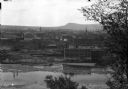
|---|---|
| Description: | View over a train stopped at a grain elevator in the foreground. The Hotel Ristau is across a street on the left, and a church building is in the distance ... |
| Date: | |
|---|---|
| Description: | Elevated view of town buildings as seen from Bancroft Tower. A body of water and what appears to be an industrial plant are in the foreground. |

| Date: | 10 24 1946 |
|---|---|
| Description: | Photographic postcard of an aerial view of town. Text below reads: "Aerial View — Boscobel, Wis." |

| Date: | 1896 |
|---|---|
| Description: | A hand-colored Map of Jefferson County, Wisconsin, shows township and section divisions, towns, villages and post offices, rural residents, railroads, road... |

| Date: | 1909 |
|---|---|
| Description: | A map of Langlade County, Wisconsin that shows townships and ranges, towns, cities and villages, wagon roads, churches, schools, sawmills, town halls, chee... |

| Date: | 1896 |
|---|---|
| Description: | A map of Milwaukee County, Wisconsin that shows the township and range system, sections, towns, roads, railroads and rail stations, cities and villages, po... |

| Date: | 1897 |
|---|---|
| Description: | This 1897 map of Sawyer County, Wisconsin, shows the township and range system, sections, roads, farm houses, camps, school houses, dams, bridges, Indian r... |

| Date: | 1920 |
|---|---|
| Description: | This map shows the township and range system, sections, schools, churches, cemeteries, town halls, roads, railroads, and lakes and streams in Shawano Count... |

| Date: | 1890 |
|---|---|
| Description: | This 1890s map shows the Wisconsin Central Railroad land grant lands owned and for sale by the Soo Line in Ashland County, Wisconsin, as well as in the eas... |

| Date: | 1972 |
|---|---|
| Description: | This map of Sheboygan County, Wisconsin, shows the location of churches in the county. Churches are indexed for each town. Also shown are sections, cities ... |

| Date: | 1960 |
|---|---|
| Description: | This mid-20th century tourist brochure for Bayfield County, Wisconsin, includes a map of the county showing towns, cities and villages, highways and roads,... |

| Date: | 1900 |
|---|---|
| Description: | This 1900 map of Waukesha County, Wisconsin, shows the township and range grid, towns, sections, cities and villages, rural landowners and acreages, railro... |

| Date: | 1928 |
|---|---|
| Description: | Shows different types of roads, railroads, schools, churches, farmsteads, cheese factories, mine shafts, old surface workings, streams, old sulphur pits, a... |

| Date: | 05 1958 |
|---|---|
| Description: | Photocopy of a map created by the City of Milwaukee Master Plan Program City Planning Division in May of 1958 representing 1870 "THE CENTRAL AREA OF THE CI... |

| Date: | 1878 |
|---|---|
| Description: | This bird’s-eye-view map of Barton is indexed for parochial and public schools, churches, a convent, the railroad depot, and the post office. |
If you didn't find the material you searched for, our Library Reference Staff can help.
Call our reference desk at 608-264-6535 or email us at: