 Filter: Categories of Wisconsin Historical Images
Filter: Subject of Railroads
Filter: Creator Name of Unknown
Filter: Community of Madison
Filter: Subject of streets
Filter: Categories of Wisconsin Historical Images
Filter: Subject of Railroads
Filter: Creator Name of Unknown
Filter: Community of Madison
Filter: Subject of streets
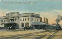
| Date: | 1910 |
|---|---|
| Description: | The Chicago & Northwestern Railway passenger depot. Caption reads: "C. & N. W. Passenger Depot, Madison, Wis." |

| Date: | 1854 |
|---|---|
| Description: | Shows street grid, sections in adjacent townships, routes of railroads and projected railroads, post offices, and creeks. Table of references identifies ma... |

| Date: | 1928 |
|---|---|
| Description: | Illustrated map of points of interest, including University buildings, parks, athletic venues, fraternity and sorority houses, and state buildings. |

| Date: | 1898 |
|---|---|
| Description: | Shows landownership, buildings, and railroads. Lake Mendota and Lake Wingra are labelled. |

| Date: | 1920 |
|---|---|
| Description: | This blue print map and blue line print copy mounted on cloth shows land ownership by name, campus buildings, local streets, railroads, and part of Lake Me... |

| Date: | 1929 |
|---|---|
| Description: | This map includes illustrations and shows campus buildings, points of interest in the surrounding area, railroads, Lake Mendota and Lake Monona. The back o... |

| Date: | 1956 |
|---|---|
| Description: | This map shows local streets, roads, railroads, highways, parks, cemeteries, hospitals, the University of Wisconsin, Middleton, Maple Bluff, Shorewood Hill... |

| Date: | 1969 |
|---|---|
| Description: | This map is pen and ink on paper and shows the location of churches, local streets, railroads, parks, Middleton, Shorewood Hills, Monona, Maple Bluff, McFa... |

| Date: | 1923 |
|---|---|
| Description: | Map showing the parcel of land on the shore of Lake Monona acquired by the City of Madison for a park (today known as Olbrich Park). |

| Date: | 1907 |
|---|---|
| Description: | This manuscript blueprint map shows land parcels pertaining to University Heights region in Madison, Wisconsin. Streets labeled included, University Avenue... |

| Date: | 1890 |
|---|---|
| Description: | Plat map of Madison, T7N R9E, including portions of the towns of Blooming Grove and Burke. Includes inset maps of South Madison, Quarrytown, Marril Park, a... |
If you didn't find the material you searched for, our Library Reference Staff can help.
Call our reference desk at 608-264-6535 or email us at: