 Filter: Categories of Wisconsin Historical Images
Filter: Subject of Railroads
Filter: Creator Name of Unknown
Filter: Community of Appleton
Filter: Categories of Wisconsin Historical Images
Filter: Subject of Railroads
Filter: Creator Name of Unknown
Filter: Community of Appleton

| Date: | 1930 |
|---|---|
| Description: | Aerial view of the city and the river. |

| Date: | |
|---|---|
| Description: | Plat map of the east central part of the city. |
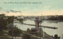
| Date: | |
|---|---|
| Description: | Elevated view of factories and railway line along the Fox River. Caption reads: "View of Water Power from Wests Park, Appleton, Wis." |

| Date: | 1952 |
|---|---|
| Description: | Map shows roads, highways, railroads, parks, city buildings, schools, cemeteries, city limits, and the Fox River. The map is indexed by street name, street... |
If you didn't find the material you searched for, our Library Reference Staff can help.
Call our reference desk at 608-264-6535 or email us at: