 Filter: Categories of Wisconsin Historical Images
Filter: Subject of Railroad tracks
Filter: Year of 1900-1999
Filter: Type of Map or Atlas
Filter: Categories of Wisconsin Historical Images
Filter: Subject of Railroad tracks
Filter: Year of 1900-1999
Filter: Type of Map or Atlas

| Date: | 1934 |
|---|---|
| Description: | This map shows industrial points of interest in Superior. The top of the map reads: "Superior, Douglas County, Wisconsin, as this Industrial Tour map indic... |

| Date: | 1968 |
|---|---|
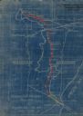
| Description: | This blue line print map shows proposed changes reserving railroad right-of-ways for future highways, land plots, as well as Lake Monona and Lake Mendota. |

| Date: | 1900 |
|---|---|
| Description: | This map shows railroad routes in red, blue, orange, brown, pink, green, and dotted, as well as lakes, rivers, and communities. The map includes a legend i... |
| Date: | 1923 |
|---|---|
| Description: | This blueprint map shows Wisconsin and Michigan-owned railroad and trackage rights from Iron Mountain to Menominee, Michigan, as well as other railroads. W... |
| Date: | 1990 |
|---|---|
| Description: | This map shows Wisconsin Central Ltd. main track, lines out of service, abandoned lines, and trackage rights. The map covers Wisconsin and Michigan's upper... |

| Date: | 1910 |
|---|---|
| Description: | This map of shows railway lines in red, with railroad land grant in Taylor, Price, and Ashland Counties shaded red, on top of the cities, counties, highway... |

| Date: | 1922 |
|---|---|
| Description: | This map shows in red the NorthWestern Railway Line routes running from Chicago, Illinois to northern Wisconsin. The map includes cities and towns, lakes, ... |

| Date: | 1952 |
|---|---|
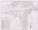
| Description: | This colored map shows the entire state, along with counties in states bordering Wisconsin. There is a key to "Wisconsin Railroads," with initials identify... |

| Date: | 1952 |
|---|---|
| Description: | This colored map shows the entire state, along with counties in states bordering Wisconsin. There is a key to "Wisconsin Railroads," with initials identify... |
If you didn't find the material you searched for, our Library Reference Staff can help.
Call our reference desk at 608-264-6535 or email us at: