 Filter: Categories of Wisconsin Historical Images
Filter: Subject of Railroad tracks
Filter: Year of 1800-1899
Filter: Year of 1850-1859
Filter: Categories of Wisconsin Historical Images
Filter: Subject of Railroad tracks
Filter: Year of 1800-1899
Filter: Year of 1850-1859
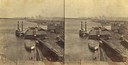
| Date: | 1858 |
|---|---|
| Description: | Elevated view of the sidewheel packet, Keokuk, at the Winona, Minnesota levee between 1858 and 1866. A barge and railway cars are in the foreground. |

| Date: | 1858 |
|---|---|
| Description: | Hölzlhuber traveled on American railways frequently and marveled that they wouldn't have been accepted as usable in Europe. This sketch of the tunnel on th... |
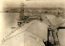
| Date: | 1850 |
|---|---|
| Description: | Elevated view of the Green Bay harbor and docks. |

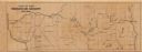
| Date: | 1855 |
|---|---|
| Description: | Drawn around 1855, this map shows the placement of railroad tracks in southern Wisconsin and northern Illinois connecting Milwaukee, Prairie du Chien, Gale... |

| Date: | 1857 |
|---|---|
| Description: | This hand-colored map shows southern Wisconsin and northern Illinois and indicates county boundaries, larger cities, and some drainage. The line was charte... |

| Date: | 1859 |
|---|---|
| Description: | Steam-powered car designed to run on ice across the Mississippi River at Prairie du Chien. The LADY FRANKLIN made one successful trip across, but wa... |
| Date: | 1850 |
|---|---|
| Description: | This map shows a cross-section of southern Wisconsin, with the Milwaukee and Mississippi Railroad line running from Milwaukee to the Mississippi River near... |

| Date: | 1853 |
|---|---|
| Description: | Map of a cross-section of southern Wisconsin, highlighting the La Crosse Milwaukee Rail Road. Shows canals, railroads, plank and post roads, and township g... |

| Date: | 1854 |
|---|---|
| Description: | This map shows the Manitowoc & Mississippi Railroad line along with other railroad lines in the Great Lakes Region. Lakes Superior, Michigan, Huron, Erie a... |

| Date: | 1855 |
|---|---|
| Description: | This map shows current and purposed railroad routes. Lake Michigan is on the far right, with Lake Superior visible at the top of the map. Routes are marked... |

| Date: | 1856 |
|---|---|
| Description: | This map shows the railroad routes and connection of the Mineral Point Railroad. Lake Michigan is on the far right, while Lake Superior is at the top of th... |

| Date: | 1856 |
|---|---|
| Description: | This map shows the railroad routes that lead to Milwaukee. Included are portions of Minnesota, Iowa and Illinois. Lake Michigan is on the right, while Lake... |

| Date: | 1857 |
|---|---|
| Description: | This map shows the railroad routes of the Milwaukee & Horicon Railroad, common roads, counties, canals, townships, cities, county towns, villages, post off... |
If you didn't find the material you searched for, our Library Reference Staff can help.
Call our reference desk at 608-264-6535 or email us at: