 Filter: Categories of Wisconsin Historical Images
Filter: Subject of Railroad tracks
Filter: Year of 1800-1899
Filter: Categories of Wisconsin Historical Images
Filter: Subject of Railroad tracks
Filter: Year of 1800-1899
| Date: | 1864 |
|---|---|
| Description: | The locomotives "Christopher Adams" and "Liverpool," taken over and operated by the U.S. military during the Civil War. |
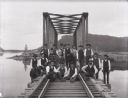
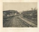
| Date: | 1890 |
|---|---|
| Description: | A railroad section crew poses with a handcar on the trestle spanning the Buffalo River, north of Alma, Wisconsin. |

| Date: | 1878 |
|---|---|
| Description: | Illustrated map of Crawford County. On the bottom right is an inset of a group of people near a train on a railroad track. |
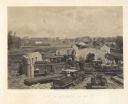
| Date: | 1866 |
|---|---|
| Description: | Elevated view of commercial area of the city, taken after General Sherman marched through. Most of the buildings appear to be intact, but one of the build... |
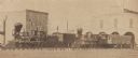
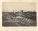
| Date: | 1866 |
|---|---|
| Description: | Elevated view of the ruins of the railroad roundhouse, with the city in the background. Men are posing on the train cars and engines. Plate 45 |
| Date: | 1864 |
|---|---|
| Description: | General Hood ordered a train full of gunpowder set on fire so that the Union Army couldn't use it, resulting in a series of explosions Plate 44 |
| Date: | 1866 |
|---|---|
| Description: | View from railroad tracks through the Allatoona Pass. One of the buildings on the left says "Grocery," and piles of lumber are stacked along the sides of t... |
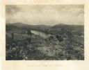
| Date: | 1866 |
|---|---|
| Description: | View towards the Allatoona Pass from behind earthworks overlooking the Etawah River. A railroad bridge crosses the river on the right. Plate 24 |

| Date: | 1875 |
|---|---|
| Description: | Winter scene with three men and a dog on railroad tracks, also a man in the far background. Two of the men are up on the snowbanks with shovels. "The Grand... |
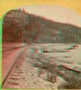
| Date: | 1874 |
|---|---|
| Description: | A yellow mount stereograph of the railroad tracks skirting the edge of Devil's Lake, with several boats tied up alongside. From the stereograph series "The... |
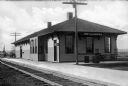
| Date: | 1880 |
|---|---|
| Description: | A view of the Weyauwega Train Depot building, platform, and railroad tracks. Signs on the building read, "Agency Western Express Co." and "Western Express ... |
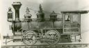
| Date: | 1875 |
|---|---|
| Description: | A builder's elevation drawing of the Hinkley railroad locomotive built for the Chicago, Milwaukee, & St. Paul Railway. |
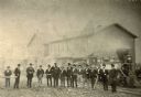
| Date: | 1872 |
|---|---|
| Description: | Employees of the West Wisconsin Railway stand in a line in front of Engine No. 12. From left to right are E.S. Graves (auditor's office clerk), A.H. Baldwi... |

| Date: | 1890 |
|---|---|
| Description: | The "J.C. Ames," a Lake Michigan car ferry, probably in the South Chicago harbor. There is a railroad bridge visible in the background. |

| Date: | 1860 |
|---|---|
| Description: | This colored map shows railroad lines east of the Mississippi as well as in the states bordering the Mississippi River. The Great Lakes and Gulf of Mexico ... |

| Date: | 1855 |
|---|---|
| Description: | Drawn around 1855, this map shows the placement of railroad tracks in southern Wisconsin and northern Illinois connecting Milwaukee, Prairie du Chien, Gale... |

| Date: | 1868 |
|---|---|
| Description: | Prepared for the State Board of Emigration in 1868, this map shows county boundaries, some cities, and completed and projected railroads. |

| Date: | 1871 |
|---|---|
| Description: | Map of Wisconsin and portions of Minnesota, Michigan, Illinois and Iowa show the major railway tracks and their connections in red and blue ink. Lakes, riv... |

| Date: | 1857 |
|---|---|
| Description: | This hand-colored map shows southern Wisconsin and northern Illinois and indicates county boundaries, larger cities, and some drainage. The line was charte... |

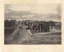
| Date: | 09 28 1895 |
|---|---|
| Description: | Elevated view of wagons filled with potatoes parked near a starch factory. In 1895, 125,000 bushels of potatoes were converted into starch. Railroad tracks... |
If you didn't find the material you searched for, our Library Reference Staff can help.
Call our reference desk at 608-264-6535 or email us at: