 Filter: Categories of Wisconsin Historical Images
Filter: Subject of Railroad tracks
Filter: Subject of transportation
Filter: Type of Map or Atlas
Filter: Categories of Wisconsin Historical Images
Filter: Subject of Railroad tracks
Filter: Subject of transportation
Filter: Type of Map or Atlas

| Date: | 1855 |
|---|---|
| Description: | This map shows current and purposed railroad routes. Lake Michigan is on the far right, with Lake Superior visible at the top of the map. Routes are marked... |

| Date: | 1856 |
|---|---|
| Description: | This map shows the railroad routes and connection of the Mineral Point Railroad. Lake Michigan is on the far right, while Lake Superior is at the top of th... |

| Date: | 1856 |
|---|---|
| Description: | This map shows the railroad routes that lead to Milwaukee. Included are portions of Minnesota, Iowa and Illinois. Lake Michigan is on the right, while Lake... |

| Date: | 1857 |
|---|---|
| Description: | This map shows the railroad routes of the Milwaukee & Horicon Railroad, common roads, counties, canals, townships, cities, county towns, villages, post off... |
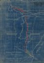
| Date: | 1923 |
|---|---|
| Description: | This blueprint map shows Wisconsin and Michigan-owned railroad and trackage rights from Iron Mountain to Menominee, Michigan, as well as other railroads. W... |
| Date: | 1990 |
|---|---|
| Description: | This map shows Wisconsin Central Ltd. main track, lines out of service, abandoned lines, and trackage rights. The map covers Wisconsin and Michigan's upper... |

| Date: | 1910 |
|---|---|
| Description: | This map of shows railway lines in red, with railroad land grant in Taylor, Price, and Ashland Counties shaded red, on top of the cities, counties, highway... |

| Date: | 1892 |
|---|---|
| Description: | This map shows the entire state with railroad routes shown in red, blue, orange, green, brown, pink, green, and black. Also labeled are counties, cities, t... |

| Date: | 1894 |
|---|---|
| Description: | This map shows the entire state with railroad routes shown in red, blue, orange, green, brown, pink, green, and black. Also labeled are counties, cities, t... |

| Date: | 1922 |
|---|---|
| Description: | This map shows in red the NorthWestern Railway Line routes running from Chicago, Illinois to northern Wisconsin. The map includes cities and towns, lakes, ... |

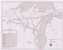
| Date: | 1952 |
|---|---|
| Description: | This colored map shows the entire state, along with counties in states bordering Wisconsin. There is a key to "Wisconsin Railroads," with initials identify... |

| Date: | 1952 |
|---|---|
| Description: | This colored map shows the entire state, along with counties in states bordering Wisconsin. There is a key to "Wisconsin Railroads," with initials identify... |
If you didn't find the material you searched for, our Library Reference Staff can help.
Call our reference desk at 608-264-6535 or email us at: