 Filter: Categories of Wisconsin Historical Images
Filter: Subject of Railroad tracks
Filter: Subject of great lakes
Filter: Categories of Wisconsin Historical Images
Filter: Subject of Railroad tracks
Filter: Subject of great lakes
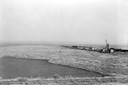
| Date: | 1936 |
|---|---|
| Description: | Elevated view of logs tugged across Lake Superior to the harbor at Ashland. |

| Date: | 1860 |
|---|---|
| Description: | This colored map shows railroad lines east of the Mississippi as well as in the states bordering the Mississippi River. The Great Lakes and Gulf of Mexico ... |

| Date: | 1855 |
|---|---|
| Description: | Drawn around 1855, this map shows the placement of railroad tracks in southern Wisconsin and northern Illinois connecting Milwaukee, Prairie du Chien, Gale... |

| Date: | 1868 |
|---|---|
| Description: | Prepared for the State Board of Emigration in 1868, this map shows county boundaries, some cities, and completed and projected railroads. |

| Date: | 1871 |
|---|---|
| Description: | Map of Wisconsin and portions of Minnesota, Michigan, Illinois and Iowa show the major railway tracks and their connections in red and blue ink. Lakes, riv... |

| Date: | 1934 |
|---|---|
| Description: | This map shows industrial points of interest in Superior. The top of the map reads: "Superior, Douglas County, Wisconsin, as this Industrial Tour map indic... |

| Date: | |
|---|---|
| Description: | Aerial view of Marinette Harbor looking out towards Lake Superior. A lighthouse and breakwater extend out into the lake. Industrial buildings, cranes, and ... |
If you didn't find the material you searched for, our Library Reference Staff can help.
Call our reference desk at 608-264-6535 or email us at: