 Filter: Categories of Wisconsin Historical Images
Filter: Subject of Railroad stations
Filter: Subject of human settlements
Filter: County of Milwaukee
Filter: Categories of Wisconsin Historical Images
Filter: Subject of Railroad stations
Filter: Subject of human settlements
Filter: County of Milwaukee
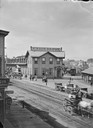
| Date: | |
|---|---|
| Description: | Elevated view across street towards the Union Depot. Horse-drawn carriages are in the street. |
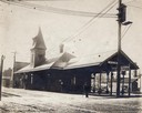
| Date: | 1910 |
|---|---|
| Description: | Chicago, Milwaukee, and St. Paul Railroad passenger depot. The village of Allis is now part of Milwaukee, Wisconsin and is called West Allis. |

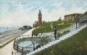
| Date: | |
|---|---|
| Description: | Elevated view across lawn with paths among trees toward the Passenger Depot with tall clock tower. Caption reads: "C. M. & St. Paul Ry. Passenger Depot, Mi... |
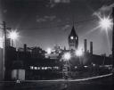
| Date: | 1950 |
|---|---|
| Description: | Nighttime image of the Depot and yard. Back of station, tracks, and a couple of trains are visible, as well as some of the buildings of Milwaukee in the ba... |
| Date: | |
|---|---|
| Description: | Train station in the distance, with a man standing in the foreground on steps leading down to the lake, near a fenced-in pond. On the left are railroad tra... |
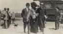
| Date: | 1897 |
|---|---|
| Description: | Two men escorting a fashionably dressed woman with a feathered boa obscuring part of her face. People are standing in the background near a train next to t... |

| Date: | 1858 |
|---|---|
| Description: | An ink on paper map of Milwaukee County and the eastern portion of Waukesha County that shows the townships of Oak Creek, Franklin, Greenfield, Wauwatosa, ... |

| Date: | 1886 |
|---|---|
| Description: | A hand-colored map of Milwaukee County, Wisconsin that shows the township and range system, sections, towns, roads, railroads and rail stations, cities and... |

| Date: | 1891 |
|---|---|
| Description: | A hand-colored map of Milwaukee County, Wisconsin that shows the township and range system, sections, towns, roads, railroads and rail stations, cities and... |

| Date: | 1902 |
|---|---|
| Description: | A map of Milwaukee County, Wisconsin that shows the township and range system, sections, towns, roads, railroads and rail stations, cities and villages, po... |

| Date: | 1968 |
|---|---|
| Description: | A tourist map of Milwaukee County and of downtown Milwaukee. The Map of Milwaukee County identifies the location of some of the points of interests in the ... |

| Date: | 1903 |
|---|---|
| Description: | Map shows railroads, roads, street car lines, schools, churches, cemeteries, town halls, and railroad stations. Includes inset lists of: Population of Milw... |

| Date: | 1915 |
|---|---|
| Description: | Text on front reads: "Elk Monument, Juneau Park and N. W. Depot, Milwaukee." Statue of an Elk on an elaborate plinth in a park with gardens, lawns and side... |
If you didn't find the material you searched for, our Library Reference Staff can help.
Call our reference desk at 608-264-6535 or email us at: