 Filter: Categories of Wisconsin Historical Images
Filter: Subject of Railroad stations
Filter: County of Milwaukee
Filter: Year of 1800-1899
Filter: Categories of Wisconsin Historical Images
Filter: Subject of Railroad stations
Filter: County of Milwaukee
Filter: Year of 1800-1899
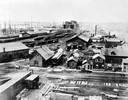
| Date: | 1865 |
|---|---|
| Description: | Elevated view of the first Milwaukee railroad depot, which was used by the Milwaukee & Waukesha and the Milwaukee & Mississippi railroads. The Milwaukee &... |
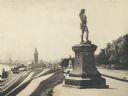
| Date: | 1895 |
|---|---|
| Description: | Side view of the statue on a plinth with Celtic designs, with his right hand holding a horn resting on his hip. The statue is located in Juneau Park. On th... |
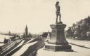
| Date: | 1893 |
|---|---|
| Description: | Statue of Leif Ericson is to the right of center in the foreground, with the figure facing the city. On the left is a hill with paths, a train station, ra... |
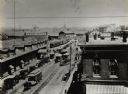
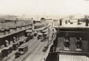
| Date: | 1886 |
|---|---|
| Description: | Elevated view of Reed Street from the corner of South Water Street. This depot served the Chicago, Milwaukee and St. Paul, the Wisconsin Central, and the M... |
| Date: | 1885 |
|---|---|
| Description: | Elevated view of Reed Street from the corner of South Water Street. This depot served the Chicago, Milwaukee and St. Paul, the Wisconsin Central, and the ... |
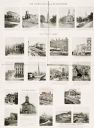
| Date: | 10 13 1895 |
|---|---|
| Description: | Twenty-one photographs of churches, city halls, courthouses, and other buildings and their locations throughout Milwaukee. |
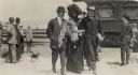
| Date: | 1897 |
|---|---|
| Description: | Two men escorting a fashionably dressed woman with a feathered boa obscuring part of her face. People are standing in the background near a train next to t... |

| Date: | 1858 |
|---|---|
| Description: | An ink on paper map of Milwaukee County and the eastern portion of Waukesha County that shows the townships of Oak Creek, Franklin, Greenfield, Wauwatosa, ... |

| Date: | 1886 |
|---|---|
| Description: | A hand-colored map of Milwaukee County, Wisconsin that shows the township and range system, sections, towns, roads, railroads and rail stations, cities and... |

| Date: | 1891 |
|---|---|
| Description: | A hand-colored map of Milwaukee County, Wisconsin that shows the township and range system, sections, towns, roads, railroads and rail stations, cities and... |

| Date: | 1891 |
|---|---|
| Description: | This maps has an index of depots, hotels, prominent institutions and buildings, churches, and places of amusement. The map was removed from an unidentified... |

| Date: | 1892 |
|---|---|
| Description: | This map shows schools, engine houses, railroads, street railways, wards, parks, cemeteries, block numbers, a street index, explanations, and general refer... |
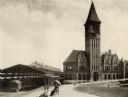
| Date: | 1892 |
|---|---|
| Description: | View of the Chicago & Northwestern Railroad station in Milwaukee. A couple is sitting on a bench under an umbrella in the foreground. The baggage car of a ... |
If you didn't find the material you searched for, our Library Reference Staff can help.
Call our reference desk at 608-264-6535 or email us at: