Filter: Categories of Wisconsin Historical Images
Filter: Subject of Railroad stations
Filter: County of Douglas
Filter: Categories of Wisconsin Historical Images
Filter: Subject of Railroad stations
Filter: County of Douglas
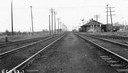
| Date: | 09 10 1939 |
|---|---|
| Description: | View down railroad tracks towards the Central Avenue depot and the railroad crossing. |

| Date: | 1899 |
|---|---|
| Description: | This 1899 map of Douglas County, Wisconsin, shows the township and range grid, towns, sections, cities, villages and railroad stations, mines, roads, railr... |

| Date: | 1896 |
|---|---|
| Description: | This 1896 map of Douglas County, Wisconsin, shows the township and range grid, the towns of Superior, Brule, Gordon, and Nebagamain, sections, cities and v... |

| Date: | 1892 |
|---|---|
| Description: | A Sanborn map of St. Louis, which is six miles southwest of South Superior. |

| Date: | 1907 |
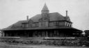
|---|---|
| Description: | Text on front reads: "C.ST.P.M. & O.R.R. Station, Superior, Wis." A girl stands in the doorway of the Chicago, St. Paul, Minneapolis and Omaha Railway trai... |
If you didn't find the material you searched for, our Library Reference Staff can help.
Call our reference desk at 608-264-6535 or email us at: