 Filter: Categories of Wisconsin Historical Images
Filter: Subject of Railroad bridges
Filter: Subject of streets
Filter: Subject of bridges
Filter: Categories of Wisconsin Historical Images
Filter: Subject of Railroad bridges
Filter: Subject of streets
Filter: Subject of bridges

| Date: | 1877 |
|---|---|
| Description: | Bird's-eye map of Janesville on the Rock River. |

| Date: | 1893 |
|---|---|
| Description: | Bird's-eye map of Jefferson, looking north. Crayfish River at left and center, Rock River from upper center to bottom center, joins at left of center; thir... |

| Date: | 1950 |
|---|---|
| Description: | An aerial view of town, showing a major industrial area. |

| Date: | 1950 |
|---|---|
| Description: | Aerial view showing shipyards, rivers and roads. |
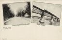
| Date: | 1905 |
|---|---|
| Description: | Postcard with two views. On the left the caption reads: "A Typical Residence Street," with a view down the street with trees and houses. On the right the c... |
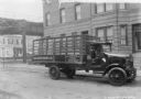
| Date: | 12 15 1923 |
|---|---|
| Description: | Passenger side view of a man sitting in a delivery truck parked on a street. In the background is an elevated highway or railroad tracks. Buildings and hou... |

| Date: | 1875 |
|---|---|
| Description: | The City of Fort Howard, Brown County, Wisconsin. Compiled from the records and drawn by F.E. Predergast, of De Pere. |

| Date: | 08 11 1950 |
|---|---|
| Description: | Aerial view of paper mill. There are bridges across the river, including a railroad bridge on the far right. |
If you didn't find the material you searched for, our Library Reference Staff can help.
Call our reference desk at 608-264-6535 or email us at: