 Filter: Categories of Wisconsin Historical Images
Filter: Subject of Railroad bridges
Filter: Subject of railroads
Filter: Subject of dwellings
Filter: Categories of Wisconsin Historical Images
Filter: Subject of Railroad bridges
Filter: Subject of railroads
Filter: Subject of dwellings

| Date: | 1877 |
|---|---|
| Description: | Bird's-eye map of Janesville on the Rock River. |

| Date: | 1893 |
|---|---|
| Description: | Bird's-eye map of Jefferson, looking north. Crayfish River at left and center, Rock River from upper center to bottom center, joins at left of center; thir... |

| Date: | 1860 |
|---|---|
| Description: | Bird's-eye view of Janesville from the High School building. |
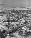
| Date: | 01 22 1949 |
|---|---|
| Description: | Aerial view of the town and the Chicago, Milwaukee, St. Paul and Pacific railroad bridge. |

| Date: | 06 1899 |
|---|---|
| Description: | Elevated view of New Richmond after the tornado hit on June 12, 1899. Many people are gathered around the railroad tracks and a few others are seen among t... |
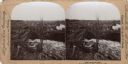
| Date: | 06 12 1899 |
|---|---|
| Description: | Elevated view of a town with a railroad bridge crossing over a river. Several individuals are visible crossing the bridge. Sign near bridge says: "Willow R... |

| Date: | |
|---|---|
| Description: | Elevated view of the city and the surrounding bay and hills. Text reads, "Terminus of Alaska C.R.R." |

| Date: | 1944 |
|---|---|
| Description: | Aerial view of the U.S. Rubber Company plant and surrounding environment. |

| Date: | 09 1884 |
|---|---|
| Description: | Sanborn map of Fort Atkinson including Barrie, Germany, and North Water Streets. |

| Date: | 1950 |
|---|---|
| Description: | Aerial view showing shipyards, rivers and roads. |
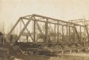
| Date: | 1906 |
|---|---|
| Description: | Steel span railroad bridge under construction over Cedar Creek. |
If you didn't find the material you searched for, our Library Reference Staff can help.
Call our reference desk at 608-264-6535 or email us at: