 Filter: Categories of Wisconsin Historical Images
Filter: Subject of Railroad bridges
Filter: Subject of railroads
Filter: Subject of architecture
Filter: Categories of Wisconsin Historical Images
Filter: Subject of Railroad bridges
Filter: Subject of railroads
Filter: Subject of architecture
| Date: | |
|---|---|
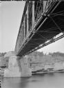
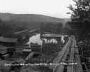
| Description: | View of the river and the underside of a railroad bridge at Kilbourn. There is a building in the background on the right just above the cliffs along the ri... |

| Date: | 1896 |
|---|---|
| Description: | Bird's-eye map of Darlington. Area bordered by Washington and North Streets, upper left hand corner, the fairgrounds, upper right corner, River Street, bot... |

| Date: | 1893 |
|---|---|
| Description: | Bird's-eye map of Jefferson, looking north. Crayfish River at left and center, Rock River from upper center to bottom center, joins at left of center; thir... |

| Date: | 1883 |
|---|---|
| Description: | Bird's-eye map of Prairie du Sac, Wisconsin with an inset of Clifton. |

| Date: | 1891 |
|---|---|
| Description: | Bird's-eye map of Stevens Point, looking east, with an inset of the Water Works. Wisconsin River in foreground with fifty-three business locations identifi... |

| Date: | 1879 |
|---|---|
| Description: | Bird's-eye map of Two Rivers. |
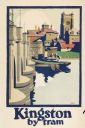
| Date: | 1925 |
|---|---|
| Description: | An original colored lithograph advertising the London Transport system, and promoting travel to "Kingston by Tram." The poster features the artist Frank N... |
| Date: | |
|---|---|
| Description: | Elevated view of an Oriental Limited train crossing The Stone Arch Bridge over a river. The bridge was built by The Great Northern Railway in 1883. There i... |

| Date: | |
|---|---|
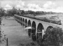
| Description: | A railroad bridge crosses over Red Cedar River. |

| Date: | |
|---|---|
| Description: | Elevated view of the city and the surrounding bay and hills. Text reads, "Terminus of Alaska C.R.R." |
| Date: | |
|---|---|
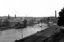
| Description: | View of the First Level Canal lined with industrial buildings featuring a paper mill,founded in 1882, on the right. A sign on the buildings reads, "Whitin... |
| Date: | 08 29 1930 |
|---|---|
| Description: | View from top of new bridge of construction grounds at the bridge site. There are cars carrying building materials on the railroad tracks by the Bridgeport... |
If you didn't find the material you searched for, our Library Reference Staff can help.
Call our reference desk at 608-264-6535 or email us at: