Filter: Categories of Wisconsin Historical Images
Filter: Subject of Railroad bridges
Filter: Subject of intellectual life
Filter: Categories of Wisconsin Historical Images
Filter: Subject of Railroad bridges
Filter: Subject of intellectual life

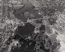
| Date: | 07 10 1949 |
|---|---|
| Description: | Aerial view of Minocqua showing the surrounding lakes. |

| Date: | 1896 |
|---|---|
| Description: | Bird's-eye map of Darlington. Area bordered by Washington and North Streets, upper left hand corner, the fairgrounds, upper right corner, River Street, bot... |

| Date: | 1877 |
|---|---|
| Description: | Bird's-eye map of Janesville on the Rock River. |

| Date: | 1893 |
|---|---|
| Description: | Bird's-eye map of Jefferson, looking north. Crayfish River at left and center, Rock River from upper center to bottom center, joins at left of center; thir... |

| Date: | 1870 |
|---|---|
| Description: | Bird's-eye map of Kilbourn City, now known as Wisconsin Dells. Kilbourn City was platted in the 1850s and received a boost when the La Crosse and Milwaukee... |

| Date: | 1870 |
|---|---|
| Description: | Bird's-eye view of the city of Manitowoc with a population of 5,168 inhabitants as it appears in 1870, the year the village was granted a city charter by t... |

| Date: | 1883 |
|---|---|
| Description: | Bird's-eye map of Prairie du Sac, Wisconsin with an inset of Clifton. |

| Date: | 1883 |
|---|---|
| Description: | Bird's-eye map of Sauk City. |

| Date: | 1891 |
|---|---|
| Description: | Bird's-eye map of Stevens Point, looking east, with an inset of the Water Works. Wisconsin River in foreground with fifty-three business locations identifi... |

| Date: | 1879 |
|---|---|
| Description: | Bird's-eye map of Two Rivers. |

| Date: | 1860 |
|---|---|
| Description: | Bird's-eye view of Janesville from the High School building. |

| Date: | 1930 |
|---|---|
| Description: | Aerial view of the city and the river. |

| Date: | 1930 |
|---|---|
| Description: | Aerial view of Carson Park, Half Moon Lake and part of the West Side in the foreground. The municipal bath house is on the lake shore in the foreground. A ... |

| Date: | 1930 |
|---|---|
| Description: | Aerial view of city, with Eau Claire River is in the foreground with Milwaukee railroad bridge at left. Gillette Rubber Co. plant is in center with Omaha r... |

| Date: | 1931 |
|---|---|
| Description: | Aerial view looking north, with a small portion of the West Side (left), nearly all of the North Side and part of the business district of the East Side. A... |

| Date: | |
|---|---|
| Description: | Aerial view of a train crossing the East River in a rural community south of Green Bay. Some buildings are visible to the right and the background of the i... |

| Date: | 1950 |
|---|---|
| Description: | An aerial view of town, showing a major industrial area. |

| Date: | 09 03 1912 |
|---|---|
| Description: | An experimental reaper(?) in a factory yard. There is a Russian name on the Reaper, and the front is set up on saw-horses. Men are working near a brick fac... |

| Date: | 1889 |
|---|---|
| Description: | Chicago & North Western Railway viaduct on the line along the Milwaukee River. The viaduct has two arched passages, and stones and rocks lining the path f... |
If you didn't find the material you searched for, our Library Reference Staff can help.
Call our reference desk at 608-264-6535 or email us at: