 Filter: Categories of Wisconsin Historical Images
Filter: Subject of Railroad bridges
Filter: Subject of church buildings
Filter: Subject of dwellings
Filter: Categories of Wisconsin Historical Images
Filter: Subject of Railroad bridges
Filter: Subject of church buildings
Filter: Subject of dwellings

| Date: | 1893 |
|---|---|
| Description: | Bird's-eye map of Jefferson, looking north. Crayfish River at left and center, Rock River from upper center to bottom center, joins at left of center; thir... |

| Date: | |
|---|---|
| Description: | Bird's-eye view of the north branch extension canal on the Susquehanna river, surrounded by smaller renderings of structures of interest around the town in... |
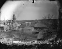
| Date: | |
|---|---|
| Description: | Elevated view of town. The tallest building is the Jackson County Court House, the church near it is the Baptist Church, and the church across the street i... |

| Date: | |
|---|---|
| Description: | Elevated panoramic view of the city of Madison, with the Wisconsin State Capitol and Lake Monona on the far left, and Picnic Point and Lake Mendota on the ... |
If you didn't find the material you searched for, our Library Reference Staff can help.
Call our reference desk at 608-264-6535 or email us at: