 Filter: Categories of Wisconsin Historical Images
Filter: Subject of Quarries and quarrying
Filter: Year of 1800-1899
Filter: Year of 1880-1889
Filter: Categories of Wisconsin Historical Images
Filter: Subject of Quarries and quarrying
Filter: Year of 1800-1899
Filter: Year of 1880-1889
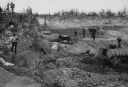
| Date: | 1888 |
|---|---|
| Description: | Men working in Horlick's stone quarry. Teams of horses pull wagons. There is a steam pump at right. A man in a hat and coat, possibly William Horlick, stan... |

| Date: | 1883 |
|---|---|
| Description: | Bird's-eye view of Montello, county seat of Marquette County. The granite quarry, woolen mill, and planing mill are clearly identified. A steamboat on Buf... |

| Date: | 1889 |
|---|---|
| Description: | This 1889 map of Douglas County, Wisconsin, shows the township and range grid, towns, sections, cities and villages, roads, existing and proposed railroads... |

| Date: | 1887 |
|---|---|
| Description: | This late 19th century map shows the lake region around Oconomowoc in Waukesha County and eastern Jefferson County, Wisconsin. Cities and villages, roads, ... |
If you didn't find the material you searched for, our Library Reference Staff can help.
Call our reference desk at 608-264-6535 or email us at: