 Filter: Categories of Wisconsin Historical Images
Filter: Subject of Quarries and quarrying
Filter: Year of 1800-1899
Filter: Year of 1870-1879
Filter: Categories of Wisconsin Historical Images
Filter: Subject of Quarries and quarrying
Filter: Year of 1800-1899
Filter: Year of 1870-1879

| Date: | 1878 |
|---|---|
| Description: | This 1878 map of Wood County, Wisconsin, shows the township and range grid, towns, sections, cities, villages and post offices, landownership, roads, railr... |

| Date: | 07 1870 |
|---|---|
| Description: | This map of Ironton is pen-and-ink on paper and shows lots and block numbers, mill, foundry buildings, limestone quarry, iron mine, and roads. Relief is sh... |

| Date: | 1873 |
|---|---|
| Description: | This map shows landownership and acreages, lot and block numbers, roads and railroads, marshes, schools, churches, mills, rural buildings, and quarries. Re... |

| Date: | 1876 |
|---|---|
| Description: | A hand-colored map on six sheets, this map of Juneau County indicates the locations of townships and sections, landowners and acreages, roads, wagon roads,... |
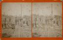
| Date: | 1878 |
|---|---|
| Description: | Stereograph of a bearded man with vest and suit posing on a narrow gauge railroad at the granite works in Montello. Workmen are posing around him. Most of ... |
If you didn't find the material you searched for, our Library Reference Staff can help.
Call our reference desk at 608-264-6535 or email us at: