 Filter: Categories of Wisconsin Historical Images
Filter: Subject of Quarries and quarrying
Filter: Subject of transportation
Filter: Categories of Wisconsin Historical Images
Filter: Subject of Quarries and quarrying
Filter: Subject of transportation

| Date: | |
|---|---|
| Description: | Man driving a red Scout pickup with white cab top. Side of passenger side door has a sign that reads: "Fred K. Betts, III Limestone Quarry." Dump trucks an... |

| Date: | 04 07 1901 |
|---|---|
| Description: | Alexander Krueger and Ernie Buelke fishing in a rowboat on the quarry pond. |

| Date: | 04 07 1901 |
|---|---|
| Description: | Ernie Buelke fishing from a rowboat on the quarry pond. |

| Date: | 1876 |
|---|---|
| Description: | A hand-colored map on six sheets, this map of Juneau County indicates the locations of townships and sections, landowners and acreages, roads, wagon roads,... |

| Date: | 1858 |
|---|---|
| Description: | This map shows city wards, streets, block and lot numbers, cemeteries, buildings, landownership, forests, railroads, a race course, quarries, and orchards.... |

| Date: | 03 20 1986 |
|---|---|
| Description: | View of Quarry Drive, a sunken path lined with trees, near Mendota Heights. Branches and stones obstruct the pathway. |

| Date: | 1969 |
|---|---|
| Description: | D-Line model pickup. 1100-D 4x4 1/2 ton pickup. In the background a crane is loading an International Pay Hauler. |

| Date: | 1969 |
|---|---|
| Description: | Slightly elevated view of a man standing with a 1/2 ton D-Line Model 1100-D 4x4 pickup. In the background a crane is loading an International Payhauler. Ro... |

| Date: | 1960 |
|---|---|
| Description: | A man stands in the foreground on the left with arm raised while a Bucyrus-Erie power shovel dumps a load into a Model 65 Payhauler. Off road rock truck. T... |

| Date: | 1960 |
|---|---|
| Description: | Right side view of a Model 65 Payhauler outdoors. A Bucyrus-Erie power shovel is dumping dirt and rock into the dump truck. The Model 65 is the smallest of... |

| Date: | 1964 |
|---|---|
| Description: | Slightly elevated view from right front of an orange F1800 Loadstar gravel dump truck. Tandem. |

| Date: | 06 12 1929 |
|---|---|
| Description: | This manuscript blueprint shows buildings with the names of their owners, tabernacle, location "where Strang found plates" and "house where Strang died," a... |
| Date: | 1897 |
|---|---|
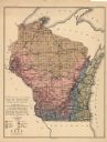
| Description: | This map shows the location of quarries throughout the state. Original caption reads, "Geology taken from General Geological Map of Wisconsin by the First ... |

| Date: | 1906 |
|---|---|
| Description: | Charles Richter, second from left, poses in front of a building at the top of the Montello granite quarry. His wife stands at the front of the group, weari... |

| Date: | 1905 |
|---|---|
| Description: | Elevated view looking west over the Montello Granite Company's works framed by an irregular mask. Two wooden derricks and irregular blocks of granite are i... |

| Date: | 1905 |
|---|---|
| Description: | A view, looking east, of the grounds and buildings of the Montello Granite Company. On the left, a train car with "Detroit Southern" painted on it stands o... |
| Date: | 1904 |
|---|---|
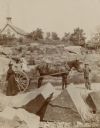
| Description: | A boy is standing and holding the bridle of a horse harnessed to an open wagon in the granite quarry. Ethel Richter, standing in the wagon with her sister ... |
| Date: | 1878 |
|---|---|
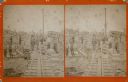
| Description: | Stereograph of a bearded man with vest and suit posing on a narrow gauge railroad at the granite works in Montello. Workmen are posing around him. Most of ... |

| Date: | 1864 |
|---|---|
| Description: | This map shows locations of quarries, sink holes, creeks, springs, rivers, houses, forts, and roads. Annotations in pencil read: "Is the top of the mound l... |

| Date: | 1864 |
|---|---|
| Description: | This map shows locations of quarries, sink holes, creeks, springs, rivers, houses, forts, and roads. The upper right corner and right margin includes anno... |
If you didn't find the material you searched for, our Library Reference Staff can help.
Call our reference desk at 608-264-6535 or email us at: