 Filter: Categories of Wisconsin Historical Images
Filter: Subject of Quarries and quarrying
Filter: Type of Map or Atlas
Filter: Categories of Wisconsin Historical Images
Filter: Subject of Quarries and quarrying
Filter: Type of Map or Atlas
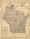
| Date: | 1897 |
|---|---|
| Description: | This map shows the location of quarries throughout the state. Original caption reads, "Geology taken from General Geological Map of Wisconsin by the First ... |

| Date: | 1864 |
|---|---|
| Description: | This map shows locations of quarries, sink holes, creeks, springs, rivers, houses, forts, and roads. Annotations in pencil read: "Is the top of the mound l... |

| Date: | 1864 |
|---|---|
| Description: | This map shows locations of quarries, sink holes, creeks, springs, rivers, houses, forts, and roads. The upper right corner and right margin includes anno... |

| Date: | 1864 |
|---|---|
| Description: | Map showing locations of quarries, sink holes, creeks, springs, rivers, houses, forts, and roads. The map appears to have been drawn on to of a plat map of... |

| Date: | 1864 |
|---|---|
| Description: | This map shows locations of quarries, sink holes, creeks, springs, rivers, houses, forts, and roads. |
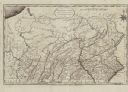
| Date: | 1795 |
|---|---|
| Description: | Map of Pennsylvania showing counties, cities, roads, quarries, roads, mountains, lakes and rivers. |
If you didn't find the material you searched for, our Library Reference Staff can help.
Call our reference desk at 608-264-6535 or email us at:
