 Filter: Categories of Wisconsin Historical Images
Filter: Subject of Public utilities
Filter: Year of 1900-1999
Filter: Year of 1970-1979
Filter: Categories of Wisconsin Historical Images
Filter: Subject of Public utilities
Filter: Year of 1900-1999
Filter: Year of 1970-1979

| Date: | 12 14 1976 |
|---|---|
| Description: | View of Lake Mendota and shoreline from University Bay Drive. Snow covers the lake and the shore. |

| Date: | 1970 |
|---|---|
| Description: | Aerial view of International Harvester's Wisconsin Steel Works, with a river and Lake Michigan in the background. |

| Date: | 02 24 1978 |
|---|---|
| Description: | "Theresa Waste Disposal System. Village man, Jim Zillmer, checks out sprinkler system." |

| Date: | 1972 |
|---|---|
| Description: | View of a man with a hard hat walking near an International truck parked in front of what appears to be a power plant. The truck is labeled with an "FPL" l... |
| Date: | 1974 |
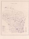
|---|---|
| Description: | This blue line map show gas services and county boundaries. Includes a legend of company names in lower left hand corner. |
| Date: | 11 1973 |
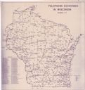
|---|---|
| Description: | This map shows the cities, county boundaries and telephone exchange locations. The map includes a numbered list of telephone companies. |
| Date: | 06 1975 |
|---|---|
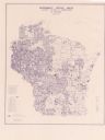
| Description: | This map shows electrical utilities and cooperatives throughout the state, as well as cities and county boundaries. The bottom left corner of the map inclu... |

| Date: | 1973 |
|---|---|
| Description: | This map is 1 of 7 and includes a location map and township diagram in the margins. The map includes a key of land type: Residential (yellow), Commercial (... |

| Date: | 1973 |
|---|---|
| Description: | This map is 2 of 7 and includes a location map and township diagram in the bottom margin. The map includes a key of land type: Residential (yellow), Commer... |

| Date: | 1973 |
|---|---|
| Description: | This map is 3 of 7 and includes a location map and township diagram in the margins. The map includes a key of land type: Residential (yellow), Commercial (... |

| Date: | 1973 |
|---|---|
| Description: | This map is 4 of 7 and includes a location map and township diagram in the left margin. The map includes a key of land type: Residential (yellow), Commerci... |

| Date: | 1973 |
|---|---|
| Description: | This map is 5 of 7 and includes a location map and township diagram in the left margin. The map includes a key of land type: Residential (yellow), Commerci... |

| Date: | 1973 |
|---|---|
| Description: | This map is 6 of 7 and includes a location map and township diagram in the bottom margin. The map includes a key of land type: Residential (yellow), Commer... |

| Date: | 1973 |
|---|---|
| Description: | This map is 7 of 7 and includes a location map and township diagram in the left margin. The map includes a key of land type: Residential (yellow), Commerci... |
If you didn't find the material you searched for, our Library Reference Staff can help.
Call our reference desk at 608-264-6535 or email us at: