 Filter: Categories of Wisconsin Historical Images
Filter: Subject of Public officers
Filter: Subject of land
Filter: Categories of Wisconsin Historical Images
Filter: Subject of Public officers
Filter: Subject of land
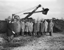
| Date: | 11 23 1948 |
|---|---|
| Description: | This ceremony at Truax Field signaled the start of construction of the 120-unit apartment project for war veterans by the Madison Housing Authority. Henry ... |

| Date: | 1922 |
|---|---|
| Description: | A road map of Milwaukee County, Wisconsin that shows the township and range system, towns, communities, completed roads, a proposed system of roads, steam ... |

| Date: | 1976 |
|---|---|
| Description: | A street map of Milwaukee County, Wisconsin that identifies the location of schools, hospitals, parks, beaches, streets, freeways, both planned or under co... |

| Date: | 1965 |
|---|---|
| Description: | A map of Milwaukee County showing the county supervisor districts and the city wards. The map also includes the names of those on the on the board of elect... |

| Date: | 1979 |
|---|---|
| Description: | David and Joan Obey (right) with Senator Gaylord Nelson (2nd from left) and Secretary of the Interior Cecil Andrus (on Nelson's left) on an Apostle Islands... |
If you didn't find the material you searched for, our Library Reference Staff can help.
Call our reference desk at 608-264-6535 or email us at: