Filter: Categories of Wisconsin Historical Images
Filter: Subject of Prisons
Filter: Subject of roads
Filter: Categories of Wisconsin Historical Images
Filter: Subject of Prisons
Filter: Subject of roads

| Date: | 1885 |
|---|---|
| Description: | Bird's-eye map of Waupun on the Rock River. There is an inset at top center of "Althouse, Wheeler & Co., Windmills and Pumps." |

| Date: | |
|---|---|
| Description: | Aerial view includes farm and orchards, surrounded by neighborhoods. A water tower is on the upper left half. |

| Date: | |
|---|---|
| Description: | View down curved road toward the prison exterior. The view is taken from a road uphill from the structure, allowing for a view of two sides of the prison. ... |

| Date: | |
|---|---|
| Description: | View across field and fences toward the refirnatory on top of a hill. A tree-covered hill rises above the complex in the background. Outbuildings are at th... |
| Date: | |
|---|---|
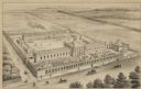
| Description: | A view of the marching parade with a band leading the way. Brick buildings line the avenue, with trees behind the property. Caption reads: "Parade Avenue -... |
| Date: | |
|---|---|
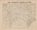
| Description: | Map covering most of Georgia and South Carolina, showing defenses along the seacoast and around the principal towns, Confederate prisons at Andersonville a... |
| Date: | |
|---|---|
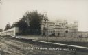
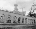
| Description: | An exterior view of the Waupun State Prison. Caption reads: "State Prison, Waupun, Wis." |
| Date: | |
|---|---|
| Description: | A couple walks outside the gates of the Waupun State Prison, built in 1854. The tower of the central building can be seen beyond the gates. |
| Date: | |
|---|---|
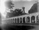
| Description: | Exterior view of Waupun State Prison, built in 1854. A woman and child are standing near the arched stone wall. Beyond the prison gates is the tower of the... |

| Date: | 1899 |
|---|---|
| Description: | This 1899 map of Dodge County, Wisconsin, shows the township and range grid, towns, sections, cities and villages, roads, railroads, post offices, cemeteri... |

| Date: | 1789 |
|---|---|
| Description: | Map of New York City showing ward boundaries, ferries, streets, roads, swamps, ponds, and rivers. The properties of Lispinard, Byards, Jones, Rutgers, and ... |

| Date: | |
|---|---|
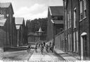
| Description: | View across road towards the gray stone reformatory. Caption reads: "State Reformatory, Green Bay, Wis." |
If you didn't find the material you searched for, our Library Reference Staff can help.
Call our reference desk at 608-264-6535 or email us at: