Filter: Categories of Wisconsin Historical Images
Filter: Subject of Prisons
Filter: Subject of human settlements
Filter: Categories of Wisconsin Historical Images
Filter: Subject of Prisons
Filter: Subject of human settlements

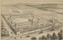
| Date: | 1885 |
|---|---|
| Description: | Bird's-eye map of Waupun on the Rock River. There is an inset at top center of "Althouse, Wheeler & Co., Windmills and Pumps." |
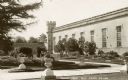
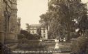
| Date: | 1920 |
|---|---|
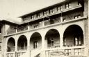
| Description: | Caption reads: "Front Yard Wis State Prison." Landscaped yard with plants in urns on the lawn near a path in the foreground. |
| Date: | 1920 |
|---|---|
| Description: | Caption reads: "Front Yard Wis State Prison Waupun Wis." |
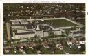
| Date: | 1915 |
|---|---|
| Description: | Aerial view of the Wisconsin State Prison. Caption reads: "Aerial View, Wisconsin State Prison, Waupun, Wis." |
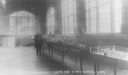
| Date: | 1900 |
|---|---|
| Description: | View of the south end of the new dining room in the Wisconsin State Prison. A man is standing next to a long table filled with plants. Large windows are al... |
| Date: | 1910 |
|---|---|
| Description: | View of the guards' room in the Wisconsin State Prison. |
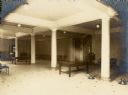
| Date: | 1905 |
|---|---|
| Description: | Caption reads: "Front Yard Wisconsin State Prison Waupun." |
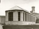
| Date: | 1910 |
|---|---|
| Description: | Exterior view of a then recently completed cell block at the State Prison. |
| Date: | 1920 |
|---|---|
| Description: | The dormitory building of the Taycheedah Industrial Home for Women. |
| Date: | 1955 |
|---|---|
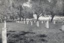
| Description: | Cemetery surrounded by trees. There is a fence and field in the distance. |

| Date: | |
|---|---|
| Description: | Aerial view includes farm and orchards, surrounded by neighborhoods. A water tower is on the upper left half. |
| Date: | |
|---|---|
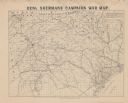
| Description: | Map covering most of Georgia and South Carolina, showing defenses along the seacoast and around the principal towns, Confederate prisons at Andersonville a... |
| Date: | |
|---|---|
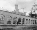
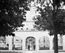
| Description: | A couple walks outside the gates of the Waupun State Prison, built in 1854. The tower of the central building can be seen beyond the gates. |
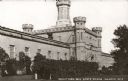
| Date: | |
|---|---|
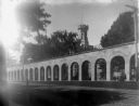
| Description: | Exterior view of Waupun State Prison, built in 1854. A woman and child are standing near the arched stone wall. Beyond the prison gates is the tower of the... |
| Date: | |
|---|---|
| Description: | Exterior view of Waupun State Prison, built in 1854. Two men are standing at the main entrance gate. Beyond the prison gates is the tower of the main build... |

| Date: | 1899 |
|---|---|
| Description: | This 1899 map of Dodge County, Wisconsin, shows the township and range grid, towns, sections, cities and villages, roads, railroads, post offices, cemeteri... |
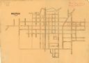
| Date: | 1898 |
|---|---|
| Description: | This is a map of Waupun in 1898 that shows labeled streets, railroads, and the location of the state prison. There are annotations on the map in what appea... |

| Date: | 1789 |
|---|---|
| Description: | Map of New York City showing ward boundaries, ferries, streets, roads, swamps, ponds, and rivers. The properties of Lispinard, Byards, Jones, Rutgers, and ... |

| Date: | 1915 |
|---|---|
| Description: | Slightly elevated view of the front gate at the Wisconsin State Prison, taken from inside the prison grounds. In the foreground is the walkway to the gate ... |
If you didn't find the material you searched for, our Library Reference Staff can help.
Call our reference desk at 608-264-6535 or email us at: