 Filter: Categories of Wisconsin Historical Images
Filter: Subject of Prairies
Filter: Subject of transportation
Filter: Year of 1900-1999
Filter: Categories of Wisconsin Historical Images
Filter: Subject of Prairies
Filter: Subject of transportation
Filter: Year of 1900-1999

| Date: | 1925 |
|---|---|
| Description: | Elevated view of Mount Vernon from the a grassy hill. |

| Date: | 1974 |
|---|---|
| Description: | This 1974 map is a reproduction of the original survey maps of the Four Lakes region of Dane County, Wisconsin. It shows sections, lakes, rivers, wetlands,... |
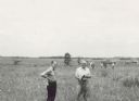
| Date: | 06 1957 |
|---|---|
| Description: | Members of the Board for the Preservation of Scientific Areas inspect the Scuppernong Prairie Scientific Area. The Board furnished this photograph for the ... |
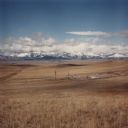
| Date: | 1986 |
|---|---|
| Description: | View across valley towards missile silo, Minuteman F-8. In the foreground is prairie, in the far background are snow-capped mountains and foothills. This... |

| Date: | 1900 |
|---|---|
| Description: | This map shows portion of the military road from Fond du Lac to the Wisconsin River near Fort Winnebago, with mile markers and adjacent land use. A few pro... |

| Date: | 1935 |
|---|---|
| Description: | A row of trucks are parked in a lot with trees in the background. The caption identifies the trucks as belonging to CCC 2670, the Madison-based 2670th Comp... |

| Date: | 06 1950 |
|---|---|
| Description: | View across a gently sloping prairie field. Trees are in the distance, and power lines and a road are on the left. The Highway Commission descriptive remar... |
If you didn't find the material you searched for, our Library Reference Staff can help.
Call our reference desk at 608-264-6535 or email us at: