 Filter: Categories of Wisconsin Historical Images
Filter: Subject of Prairies
Filter: Subject of transportation
Filter: Creator Name of Unknown
Filter: Categories of Wisconsin Historical Images
Filter: Subject of Prairies
Filter: Subject of transportation
Filter: Creator Name of Unknown

| Date: | 1836 |
|---|---|
| Description: | The top map is the "Plat of Madison the Capitol of Wisconsin." The bottom map is the "Map of the Four Lake Country. Taken from the Township Maps in the U.S... |
| Date: | |
|---|---|
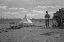
| Description: | View of a camp with a cook standing at the back end of a chuckwagon with a large bowl in front of him. To the left is a pile of logs, along with some pots.... |

| Date: | 1873 |
|---|---|
| Description: | This map shows lots and blocks, additions and subdivisions, and large-scale landownership. The map is oriented with north to the upper right. The map is fr... |
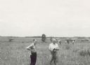
| Date: | 06 1957 |
|---|---|
| Description: | Members of the Board for the Preservation of Scientific Areas inspect the Scuppernong Prairie Scientific Area. The Board furnished this photograph for the ... |

| Date: | 1838 |
|---|---|
| Description: | This map is a development plat that shows street names, numbered blocks and lots, and small farm lot owners. Included on the right of the map is a large am... |

| Date: | 1935 |
|---|---|
| Description: | A row of trucks are parked in a lot with trees in the background. The caption identifies the trucks as belonging to CCC 2670, the Madison-based 2670th Comp... |
If you didn't find the material you searched for, our Library Reference Staff can help.
Call our reference desk at 608-264-6535 or email us at: